Topografische Karte Ledston
Interaktive Karte
Klicken Sie auf die Karte, um die Höhe anzuzeigen.
Über diese Karte
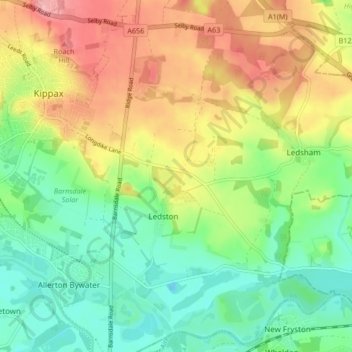
Name: Topografische Karte Ledston, Höhe, Relief.
Ort: Ledston, Leeds, West Yorkshire, England, United Kingdom (53.73369 -1.35556 53.78320 -1.32442)
Durchschnittliche Höhe: 45 m
Minimale Höhe: -1 m
Maximale Höhe: 106 m
Andere topografische Karten
Klicken Sie auf eine Karte, um ihre Topografie, ihre Höhe und ihr Relief anzuzeigen.
Churwell
United Kingdom > England > Leeds
Churwell, Leeds, West Yorkshire, England, LS27 7QR, United Kingdom
Durchschnittliche Höhe: 96 m
East Rigton
United Kingdom > England > Leeds
East Rigton, Leeds, West Yorkshire, England, LS17 9AZ, United Kingdom
Durchschnittliche Höhe: 72 m
Bramhope
United Kingdom > England > Leeds > Bramhope
Bramhope, Leeds, West Yorkshire, England, United Kingdom
Durchschnittliche Höhe: 143 m
Boston Spa
United Kingdom > England > Leeds > Wetherby
Boston Spa, Wetherby, Leeds, West Yorkshire, England, United Kingdom
Durchschnittliche Höhe: 34 m
Kippax
United Kingdom > England > Leeds > Great Preston
Kippax, Great Preston, Leeds, West Yorkshire, England, United Kingdom
Durchschnittliche Höhe: 56 m
Yeadon
United Kingdom > England > Leeds
Yeadon, Leeds, West Yorkshire, England, LS19 7RS, United Kingdom
Durchschnittliche Höhe: 142 m
Guiseley
United Kingdom > England > Leeds
Guiseley, Leeds, West Yorkshire, England, LS20 9FN, United Kingdom
Durchschnittliche Höhe: 140 m
Limekiln
United Kingdom > England > Leeds
Limekiln, Leeds, Yorkshire and the Humber, England, LS15 4DF, United Kingdom
Durchschnittliche Höhe: 89 m