
Topografische Karte San Luis Potosí
Interaktive Karte
Klicken Sie auf die Karte, um die Höhe anzuzeigen.
Über diese Karte
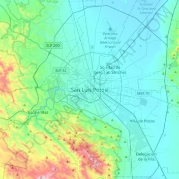
Name: Topografische Karte San Luis Potosí, Höhe, Relief.
Durchschnittliche Höhe: 2.004 m
Minimale Höhe: 1.826 m
Maximale Höhe: 2.855 m
San Luis Potosí, commonly called SLP or simply San Luis, is the capital and the most populous city of the Mexican state of San Luis Potosí. It is the municipal seat of the surrounding municipality of San Luis Potosí. The city lies at an elevation of 1,864 metres (6,115 feet). It has an estimated population of 824,229 in the city proper and a population of approximately 1,221,526 in its metropolitan area, formed with the neighbour city of Soledad de Graciano Sánchez and other surrounding municipalities, which makes the metropolitan area of Greater San Luis Potosí the eleventh largest in Mexico.
Andere topografische Karten
Klicken Sie auf eine Karte, um ihre Topografie, ihre Höhe und ihr Relief anzuzeigen.
Rotonda Florida
Mexico > San Luis Potosi > Municipio de San Luis Potosí
Rotonda Florida, Bosques La Florida, Municipio de San Luis Potosí, San Luis Potosi, Mexico
Durchschnittliche Höhe: 1.853 m