
Spenden
Topografische Karte Frederick County
Klicken Sie auf die Karte, um die Höhe anzuzeigen.
Spenden
Über diese Karte
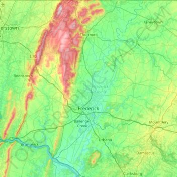
Name: Topografische Karte Frederick County, Höhe, Relief.
Ort: Frederick County, Maryland, United States (39.22009 -77.67736 39.72003 -77.10673)
Durchschnittliche Höhe: 186 m
Minimale Höhe: 43 m
Maximale Höhe: 645 m
Spenden
Andere topografische Karten
Klicken Sie auf eine Karte, um ihre Topografie, ihre Höhe und ihr Relief anzuzeigen.
Baltimore
United States > Maryland > Baltimore
Baltimore is in north-central Maryland on the Patapsco River close to where it empties into the Chesapeake Bay. The city is also located on the fall line between the Piedmont Plateau and the Atlantic coastal plain, which divides Baltimore into "lower city" and "upper city". The city's elevation ranges from sea…
Durchschnittliche Höhe: 65 m
Spenden
Spenden
Winchester-on-the-Severn
United States > Maryland > Anne Arundel County > Arnold
Durchschnittliche Höhe: 16 m
Spenden
Damascus
United States > Maryland > Montgomery County
As an unincorporated area, Damascus' boundaries are not officially defined. Damascus is recognized by the United States Census Bureau as a census-designated place, and by the United States Geological Survey as a populated place located. Damascus proper is a locally high spot at 847 ft (258m) above sea level,…
Durchschnittliche Höhe: 204 m
Severn Heights
United States > Maryland > Anne Arundel County > Severna Park
Durchschnittliche Höhe: 12 m
Spenden
Spenden
Monocacy River
United States > Maryland > Frederick County > Buckeystown
Durchschnittliche Höhe: 121 m
Spenden
Spenden
Piney Ridge Village
United States > Maryland > Carroll County > Eldersburg
Durchschnittliche Höhe: 182 m
Spenden
Catoctin Mountain
United States > Maryland > Frederick County
Catoctin Mountain traverses Frederick County, Maryland and extends into northern Loudoun County, Virginia. It rises to its greatest elevation of 1,900 feet (580 m) above sea level just southwest of Cunningham Falls State Park and is transected by gaps at Braddock Heights (Fairview Pass), Point of Rocks on the…
Durchschnittliche Höhe: 471 m
Spenden
Spenden
Edinboro Estates
United States > Maryland > Anne Arundel County > Glen Burnie
Durchschnittliche Höhe: 24 m
Hydes Road Park
United States > Maryland > Baltimore County > Baldwin > Jenkins
Durchschnittliche Höhe: 112 m
Spenden
Spenden
Highland
United States > Maryland > Frederick County
The majority of the downtown Highland district is situated within the 418-acre (169 ha) land grant named "Hickory Ridge". The Rouse Company borrowed the land grant name for one of its nearby villages of Columbia, built in 1974. The historic "White Hall" or "Hickory Ridge" estate (1749) was owned by the…
Durchschnittliche Höhe: 357 m
Spenden
Spenden
Spenden
Cypress Creek
United States > Maryland > Anne Arundel County > Severna Park
Durchschnittliche Höhe: 8 m
Spenden
Spenden
Spenden
Spenden
Spenden
Stout Bottle Branch
United States > Maryland > Harford County > Chestnut Hill
Durchschnittliche Höhe: 95 m
Spenden
Eastern Neck National Wildlife Refuge
United States > Maryland > Kent County
Durchschnittliche Höhe: 1 m
Spenden
Turkey Ridge
United States > Maryland > Calvert County > Prince Frederick
Durchschnittliche Höhe: 37 m
Spenden
Spenden
Spenden