
Spenden
Topografische Karte Sanganer Tehsil
Klicken Sie auf die Karte, um die Höhe anzuzeigen.
Spenden
Über diese Karte
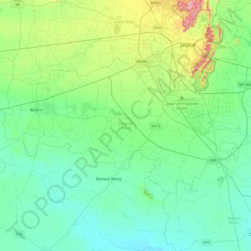
Name: Topografische Karte Sanganer Tehsil, Höhe, Relief.
Ort: Sanganer Tehsil, Jaipur, Rajasthan, India (26.67220 75.48148 26.89360 75.93857)
Durchschnittliche Höhe: 366 m
Minimale Höhe: 294 m
Maximale Höhe: 647 m
Spenden
Andere topografische Karten
Klicken Sie auf eine Karte, um ihre Topografie, ihre Höhe und ihr Relief anzuzeigen.
Spenden
Spenden
Spenden
Spenden
Bikaner
India > Rajasthan > Bikaner Tehsil
Around a century after Rao Bika founded Bikaner, the state's fortunes flourished under the sixth Raja, Rai Singhji, who ruled from 1571 to 1611. During the Mughal Empire's rule in the country, Raja Rai Singh accepted the suzerainty of the Mughals and held a high rank as an army general at the court of the…
Durchschnittliche Höhe: 225 m
Spenden
Udaipur
India > Rajasthan > Girwa Tehsil
Udaipur is located at 24°31′30″N 73°40′38″E / 24.525049°N 73.677116°E / 24.525049; 73.677116. The city covers an area of 64 km2 (25 sq mi) and lies at an altitude of 598.00 m (1,962 ft) above sea level. It is located in the southern region of Rajasthan, near the Gujarat border. The city…
Durchschnittliche Höhe: 656 m
Spenden
Haldighati Park
India > Rajasthan > Sanganer Tehsil > Jaipur Municipal Corporation
Durchschnittliche Höhe: 372 m
Spenden
Baran
India > Rajasthan > Baran Tehsil
Baran is located at 25°06′N 76°31′E / 25.1°N 76.52°E / 25.1; 76.52. It has an average elevation of 262 metres (859 ft). It is surrounded by three Rivers Kalisindh, Parvati and Parban. The city is situated on the border of Rajasthan and Madhya Pradesh.
Durchschnittliche Höhe: 264 m
Spenden
Spenden
Spenden
Spenden
Pratapgarh
India > Rajasthan > Pratapgarh Tehsil
Pratapgarh District is a newly constituted district in Rajasthan state. it came into existence on 26 January 2008, as the 33rd district of Rajasthan. Pratapgarh is located at 24.03° N 74.78° E. It has an average elevation of 491 metres (1610 feet). It is said to be the second highest place in Rajasthan after…
Durchschnittliche Höhe: 503 m
Nathdwara
India > Rajasthan > Nathdwara Tehsil
Nathdwara is located at 24°56′N 73°49′E / 24.93°N 73.82°E / 24.93; 73.82. It has an average elevation of 584 metres (1919 ft). Located just 48 km north-east of Udaipur in Rajasthan, this town is easily reached by air, road or nearest rail-head.
Durchschnittliche Höhe: 590 m
Spenden
Spenden
Khetri
India > Rajasthan > Khetri Tehsil
Khetri is located at 27°59′N 75°48′E / 27.98°N 75.8°E / 27.98; 75.8. It has an average elevation of 484 metres (1587 feet). The name of the mountain in Khetri is Bhopalgarh.
Durchschnittliche Höhe: 452 m
Spenden
Balotra
India > Rajasthan > Pachpadra Tehsil
Balotra is located at 25°50′N 72°14′E / 25.83°N 72.23°E / 25.83; 72.23. It has an average elevation of 106 metres (347 feet).
Durchschnittliche Höhe: 124 m
Spenden
Spenden
Spenden
Kumbhalgarh Fort
India > Rajasthan > Kumbhalgarh Tehsil > Quila Kumbhalgarh > Aret
Durchschnittliche Höhe: 876 m
Spenden
Spenden
Spenden
Spenden
Spenden
Spenden
Spenden
Ranvir shekhawat park
India > Rajasthan > Sanganer Tehsil > Jaipur Municipal Corporation
Durchschnittliche Höhe: 413 m
Spenden