
Spenden
Topografische Karte Lagoa dos Gatos
Klicken Sie auf die Karte, um die Höhe anzuzeigen.
Spenden
Über diese Karte
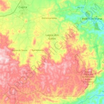
Name: Topografische Karte Lagoa dos Gatos, Höhe, Relief.
Durchschnittliche Höhe: 522 m
Minimale Höhe: 183 m
Maximale Höhe: 861 m
Spenden
Andere topografische Karten
Klicken Sie auf eine Karte, um ihre Topografie, ihre Höhe und ihr Relief anzuzeigen.
Praça Farias Neves
Brazil > Pernambuco > Região Metropolitana do Recife > Recife
Durchschnittliche Höhe: 22 m
Academia da Cidade - Chã de Alegria
Brazil > Pernambuco > Chã de Alegria
Durchschnittliche Höhe: 134 m
Spenden
Ana de Alburquerque
Brazil > Pernambuco > Região Metropolitana do Recife > Igarassu
Durchschnittliche Höhe: 17 m
Boa Paz
Brazil > Pernambuco > Região Administrativa Integrada de Desenvolvimento do Polo Petrolina e Juazeiro > Petrolina
Durchschnittliche Höhe: 379 m
Fernando de Noronha
Fernando de Noronha (Portuguese pronunciation: [feʁˈnɐ̃du dʒi noˈɾoɲɐ]) is an archipelago in the Atlantic Ocean, part of the State of Pernambuco, Brazil, and located 354 km (191 nmi; 220 mi) off the Brazilian coast. It consists of 21 islands and islets, extending over an area of 26 km2 (10 sq mi).…
Durchschnittliche Höhe: 4 m
Spenden
Saint Peter and Saint Paul Archipelago
The Saint Peter and Saint Paul Rocks are situated in the Atlantic Ocean, 100 km (62 mi) north of the Equator, and are the only group of Brazilian oceanic islets in the Northern Hemisphere. The nearest point in the Brazilian coast, is Cabo do Calcanhar, Rio Grande do Norte, approximately 1,010 kilometres (630…
Durchschnittliche Höhe: 0 m