
Spenden
Topografische Karte Binangonan
Klicken Sie auf die Karte, um die Höhe anzuzeigen.
Spenden
Über diese Karte
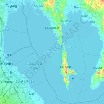
Name: Topografische Karte Binangonan, Höhe, Relief.
Ort: Binangonan, Rizal, Calabarzon, Philippines (14.24986 121.11835 14.54175 121.28243)
Durchschnittliche Höhe: 17 m
Minimale Höhe: -4 m
Maximale Höhe: 405 m
Spenden
Andere topografische Karten
Klicken Sie auf eine Karte, um ihre Topografie, ihre Höhe und ihr Relief anzuzeigen.
Antipolo
Its higher elevation than that of Metro Manila affords it a scenic view of the metropolis, especially at night. Its locally grown mangoes and cashews are popular among tourists, as well as suman – a local delicacy made out of glutinous rice. The Hinulugang Taktak National Park, which was once a popular…
Durchschnittliche Höhe: 125 m
Spenden
Spenden
Spenden
San Mateo
Philippines > Rizal > San Mateo
The main source of the municipality's water supply are deep wells, pump wells (operated by Manila Water), open wells, springs and other ground water resources. Some of the elevated parts of the municipality are under watershed protected areas since the topography is characterized by rolling to mountainous…
Durchschnittliche Höhe: 68 m