
Vielen Dank für die Unterstützung dieser Website ❤️
Spenden
Spenden
Topografische Karte Rāmnagar
Klicken Sie auf die Karte, um die Höhe anzuzeigen.
Vielen Dank für die Unterstützung dieser Website ❤️
Spenden
Spenden
Rāmnagar
It has an average elevation of roughly 345 metres (1,132 feet). Ramnagar is located at the foothills of the Himalayas on the bank of river Kosi. The town is visited by many tourists due to its geographical location near Corbett National Park. Its proximity to Nainital which is a famous hill station of Northern India makes it even more popular. There is a Barrage on Kosi River in Ramnagar where many migratory birds such as Ruddy Shelduck arrive in winter.
Vielen Dank für die Unterstützung dieser Website ❤️
Spenden
Spenden
Über diese Karte
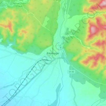
Name: Topografische Karte Rāmnagar, Höhe, Relief.
Ort: Rāmnagar, Ramnagar, Nainital, Uttarakhand, 244715, India (29.35484 79.08693 29.43484 79.16693)
Durchschnittliche Höhe: 391 m
Minimale Höhe: 303 m
Maximale Höhe: 640 m
Vielen Dank für die Unterstützung dieser Website ❤️
Spenden
Spenden