
Topografische Karte Freedom Park
Interaktive Karte
Klicken Sie auf die Karte, um die Höhe anzuzeigen.
Über diese Karte
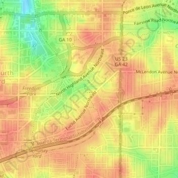
Name: Topografische Karte Freedom Park, Höhe, Relief.
Durchschnittliche Höhe: 306 m
Minimale Höhe: 268 m
Maximale Höhe: 323 m
Andere topografische Karten
Klicken Sie auf eine Karte, um ihre Topografie, ihre Höhe und ihr Relief anzuzeigen.
Grant Park
United States of America > Georgia > Atlanta
Grant Park, Cabbage Town, Thomasville, Atlanta, Fulton County, Georgia, United States of America
Durchschnittliche Höhe: 298 m
Adams Park
United States of America > Georgia > Atlanta > Adams Park
Adams Park, Atlanta, Fulton County, Georgia, 30311, United States of America
Durchschnittliche Höhe: 295 m
Vine City
United States of America > Georgia > Atlanta > Vine City
Vine City, Atlanta, Fulton County, Georgia, 30313, United States of America
Durchschnittliche Höhe: 301 m