Geolokalisieren
👉 Easily get elevation data in JSON, GeoTIFF and KML formats using Elevation API
Vielen Dank für die Unterstützung dieser Website ❤️
Spenden

Topografische Karte Mount Eagle

Klicken Sie auf die Karte, um die Höhe anzuzeigen.

👉 Easily get elevation data in JSON, GeoTIFF and KML formats using Elevation API
Vielen Dank für die Unterstützung dieser Website ❤️
Spenden

Über diese Karte

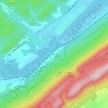
Name: Topografische Karte Mount Eagle, Höhe, Relief.

Ort: Mount Eagle, Howard Township, Centre County, Pennsylvania, United States (40.96217 -77.72550 41.00217 -77.68550)

Durchschnittliche Höhe: 290 m

Minimale Höhe: 190 m

Maximale Höhe: 519 m

👉 Easily get elevation data in JSON, GeoTIFF and KML formats using Elevation API
Vielen Dank für die Unterstützung dieser Website ❤️
Spenden

Andere topografische Karten

Klicken Sie auf eine Karte, um ihre Topografie, ihre Höhe und ihr Relief anzuzeigen.

Spring Mills

United States > Pennsylvania > Centre County

Durchschnittliche Höhe: 368 m

Zion

United States > Pennsylvania > Centre County

Durchschnittliche Höhe: 361 m

Worth Township

United States > Pennsylvania > Centre County

Durchschnittliche Höhe: 456 m

Beech Creek

United States > Pennsylvania > Centre County

Durchschnittliche Höhe: 450 m

Vielen Dank für die Unterstützung dieser Website ❤️
Spenden

Port Matilda

United States > Pennsylvania > Centre County

Durchschnittliche Höhe: 360 m

Julian

United States > Pennsylvania > Centre County

Durchschnittliche Höhe: 327 m

Philipsburg

United States > Pennsylvania > Centre County

Durchschnittliche Höhe: 456 m

Boalsburg

United States > Pennsylvania > Centre County > Boalsburg

Durchschnittliche Höhe: 426 m

Vielen Dank für die Unterstützung dieser Website ❤️
Spenden

Milesburg

United States > Pennsylvania > Centre County

Durchschnittliche Höhe: 258 m

Coburn

United States > Pennsylvania > Centre County

Durchschnittliche Höhe: 364 m

Halfmoon Township

United States > Pennsylvania > Centre County

Durchschnittliche Höhe: 396 m

Milheim Narrows

United States > Pennsylvania > Centre County

Durchschnittliche Höhe: 439 m

Vielen Dank für die Unterstützung dieser Website ❤️
Spenden

Aaronsburg

United States > Pennsylvania > Centre County

Durchschnittliche Höhe: 390 m

Blanchard

United States > Pennsylvania > Centre County

Durchschnittliche Höhe: 201 m

Clarence

United States > Pennsylvania > Centre County

Durchschnittliche Höhe: 471 m

Lemont

United States > Pennsylvania > Centre County

Durchschnittliche Höhe: 344 m

Vielen Dank für die Unterstützung dieser Website ❤️
Spenden

Madisonburg

United States > Pennsylvania > Centre County

Durchschnittliche Höhe: 429 m

Rebersburg

United States > Pennsylvania > Centre County

Durchschnittliche Höhe: 421 m

Sandy Ridge

United States > Pennsylvania > Centre County

Sandy Ridge is located in Pennsylvania, at 40°48′43″N 78°13′56″W / 40.81194°N 78.23222°W / 40.81194; -78.23222 (40.811904, -78.232142), southwest of the center of Rush Township. It sits at an elevation of 1,800 to 1,950 feet (550 to 590 m), 3 miles (5 km) northwest of the physical Sandy…

Durchschnittliche Höhe: 576 m

Vielen Dank für die Unterstützung dieser Website ❤️
Spenden

Bald Eagle State Park

United States > Pennsylvania > Centre County

Foster Joseph Sayers Reservoir is a 1,730-acre (700 ha) reservoir that was built in 1971 by the U.S. Army Corps of Engineers as part of a flood control project on the Susquehanna River basin. The lake was created by damming Bald Eagle Creek. It stretches upstream for 8 miles (12.87 km) and has 23 miles (37.01…

Durchschnittliche Höhe: 290 m

Snow Shoe

United States > Pennsylvania > Centre County

Durchschnittliche Höhe: 511 m

Vielen Dank für die Unterstützung dieser Website ❤️
Spenden