
Vielen Dank für die Unterstützung dieser Website ❤️
Spenden
Spenden
Topografische Karte Elvas
Klicken Sie auf die Karte, um die Höhe anzuzeigen.
Vielen Dank für die Unterstützung dieser Website ❤️
Spenden
Spenden
Elvas
Assim, o clima, de feição mediterrânico, apresenta aqui uma secura estival acentuada e um Outono e Inverno pluviosos, obviamente, não tão pluviosos como em certas regiões do país, de superior altitude ou mais próximas da influência oceânica.
Vielen Dank für die Unterstützung dieser Website ❤️
Spenden
Spenden
Über diese Karte
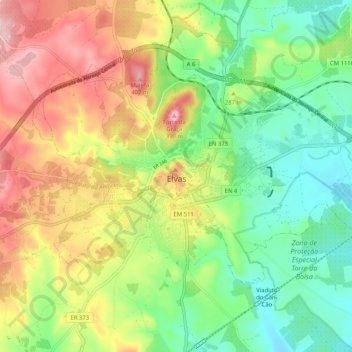
Name: Topografische Karte Elvas, Höhe, Relief.
Durchschnittliche Höhe: 275 m
Minimale Höhe: 180 m
Maximale Höhe: 411 m
Vielen Dank für die Unterstützung dieser Website ❤️
Spenden
Spenden