
Spenden
Topografische Karte Mount Mitchell
Klicken Sie auf die Karte, um die Höhe anzuzeigen.
Spenden
Mount Mitchell
Mount Mitchell, known in Cherokee as Attakulla, is the highest peak of the Appalachian Mountains and the highest peak in mainland eastern North America. It is located near Burnsville in Yancey County, North Carolina; in the Black Mountain subrange of the Appalachians, about 19 miles (31 km) northeast of Asheville. It is protected by Mount Mitchell State Park and surrounded by the Pisgah National Forest. Mount Mitchell's elevation is 6,684 feet (2,037 m) above sea level.
Spenden
Über diese Karte
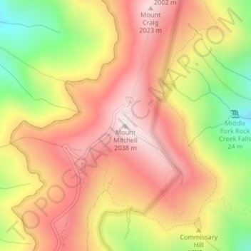
Name: Topografische Karte Mount Mitchell, Höhe, Relief.
Ort: Mount Mitchell, Yancey County, North Carolina, United States (35.76491 -82.26517 35.76501 -82.26507)
Durchschnittliche Höhe: 1.743 m
Minimale Höhe: 1.355 m
Maximale Höhe: 2.019 m
Spenden
Andere topografische Karten
Klicken Sie auf eine Karte, um ihre Topografie, ihre Höhe und ihr Relief anzuzeigen.
Mount Mitchell State Park
United States > North Carolina > Yancey County > Burnsville
In addition to Mount Mitchell itself, the park encompasses several other peaks which top out at over 6,000 feet (1,800 m) in elevation, including Mount Hallback, Mount Craig (just 52 feet (16 m) shy of Mount Mitchell in elevation and the second highest peak east of the Mississippi River), Big Tom and Balsam…
Durchschnittliche Höhe: 1.271 m
Spenden
South Toe River
United States > North Carolina > Yancey County > Hamrick
Durchschnittliche Höhe: 920 m