
Topografische Karte Lhasa
Interaktive Karte
Klicken Sie auf die Karte, um die Höhe anzuzeigen.
Über diese Karte
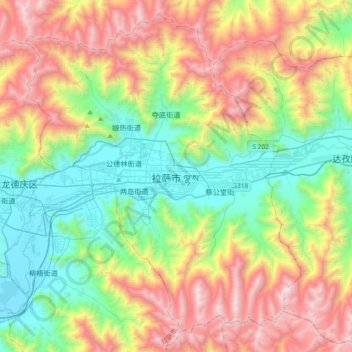
Name: Topografische Karte Lhasa, Höhe, Relief.
Ort: Lhasa, Chengguan District, Lhasa, Tibet, 850000, China (29.49539 91.01047 29.81539 91.33047)
Durchschnittliche Höhe: 4.380 m
Minimale Höhe: 3.615 m
Maximale Höhe: 5.654 m
Lhasa has an elevation of about 3,600 m (11,800 ft) and lies in the centre of the Tibetan Plateau with the surrounding mountains rising to 5,500 m (18,000 ft). The air only contains 68 percent of the oxygen compared to sea level. The Lhasa River, also Kyi River or Kyi Chu, a tributary of the Yarlung Zangbo River (Brahmaputra River), runs through the southern part of the city. This river, known to local Tibetans as the "merry blue waves", flows through the snow-covered peaks and gullies of the Nyainqêntanglha mountains, extending 315 km (196 mi), and emptying into the Yarlung Zangbo River at Qüxü, forms an area of great scenic beauty. The marshlands, mostly uninhabited, are to the north. Ingress and egress roads run east and west, while to the north, the road infrastructure is less developed.