
Topografische Karte Yancey County
Interaktive Karte
Klicken Sie auf die Karte, um die Höhe anzuzeigen.
Über diese Karte
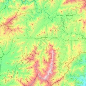
Name: Topografische Karte Yancey County, Höhe, Relief.
Ort: Yancey County, North Carolina, VS (35.70148 -82.50391 36.08459 -82.13306)
Durchschnittliche Höhe: 969 m
Minimale Höhe: 397 m
Maximale Höhe: 2.011 m
Andere topografische Karten
Klicken Sie auf eine Karte, um ihre Topografie, ihre Höhe und ihr Relief anzuzeigen.
Buies Creek
VS > North Carolina > Buies Creek
Buies Creek, Harnett County, North Carolina, 27506, VS
Durchschnittliche Höhe: 61 m
Mount Mitchell
Mount Mitchell, Yancey County, North Carolina, VS
Durchschnittliche Höhe: 1.743 m
Mecklenburg County
Mecklenburg County, North Carolina, VS
Durchschnittliche Höhe: 208 m