
Topografische Karte Telluride
Interaktive Karte
Klicken Sie auf die Karte, um die Höhe anzuzeigen.
Über diese Karte
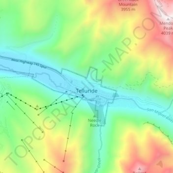
Name: Topografische Karte Telluride, Höhe, Relief.
Durchschnittliche Höhe: 3.125 m
Minimale Höhe: 2.647 m
Maximale Höhe: 4.023 m
Telluride has an elevation of 8,750 feet (2,670 m) in an isolated spot in Southwest Colorado. From the west, Colorado Route 145 is the most common way into Telluride; two other passes enter the town, Imogene Pass and Black Bear Pass.
Andere topografische Karten
Klicken Sie auf eine Karte, um ihre Topografie, ihre Höhe und ihr Relief anzuzeigen.
Silver Lake
United States > Colorado > San Miguel County
Silver Lake, San Miguel County, Colorado, United States
Durchschnittliche Höhe: 3.459 m
Specie Mesa
United States > Colorado > San Miguel County
Specie Mesa, San Miguel County, Colorado, United States
Durchschnittliche Höhe: 2.933 m
Mountain Village
United States > Colorado > San Miguel County
Mountain Village, San Miguel County, Colorado, United States
Durchschnittliche Höhe: 2.917 m
Telluride
United States > Colorado > San Miguel County > Telluride
Telluride, San Miguel County, Colorado, 8145, United States
Durchschnittliche Höhe: 3.246 m
Norwood
United States > Colorado > San Miguel County > Norwood
Norwood, San Miguel County, Colorado, 81325, United States
Durchschnittliche Höhe: 2.148 m
Placerville
United States > Colorado > San Miguel County > Placerville
Placerville, San Miguel County, Colorado, 81430, United States
Durchschnittliche Höhe: 2.460 m