
Topografische Karte Rudford
Klicken Sie auf die Karte, um die Höhe anzuzeigen.
Über diese Karte
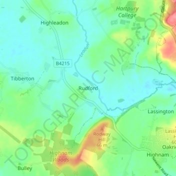
Name: Topografische Karte Rudford, Höhe, Relief.
Durchschnittliche Höhe: 27 m
Minimale Höhe: 6 m
Maximale Höhe: 81 m
Andere topografische Karten
Klicken Sie auf eine Karte, um ihre Topografie, ihre Höhe und ihr Relief anzuzeigen.
Redmarley D'Abitot
United Kingdom > England > Gloucestershire > Forest of Dean
Durchschnittliche Höhe: 46 m
Newent Woods
United Kingdom > England > Gloucestershire > Forest of Dean > May Hill
Durchschnittliche Höhe: 157 m
Speech House Lake
United Kingdom > England > Gloucestershire > Forest of Dean
Durchschnittliche Höhe: 148 m
Newland
United Kingdom > England > Gloucestershire > Forest of Dean > Newland
Durchschnittliche Höhe: 151 m
Westbury-on-Severn
United Kingdom > England > Gloucestershire > Forest of Dean
Durchschnittliche Höhe: 25 m
Aylburton
United Kingdom > England > Gloucestershire > Forest of Dean > Aylburton
Durchschnittliche Höhe: 37 m
Lydney Harbour
United Kingdom > England > Gloucestershire > Forest of Dean > Lydney > Naas
Durchschnittliche Höhe: 7 m
Land Grove
United Kingdom > England > Gloucestershire > Forest of Dean > Mitcheldean
Durchschnittliche Höhe: 157 m
Coleford
United Kingdom > England > Gloucestershire > Forest of Dean > Coleford
Durchschnittliche Höhe: 193 m
Cinderford
United Kingdom > England > Gloucestershire > Forest of Dean > Littledean
Durchschnittliche Höhe: 173 m