
Spenden
Topografische Karte Contagem
Klicken Sie auf die Karte, um die Höhe anzuzeigen.
Spenden
Contagem
The city belongs to the metropolitan mesoregion and to the microregion of Belo Horizonte, has a territorial extension of 195.2 square kilometres (75.4 square miles), and borders the municipalities of Ribeirão das Neves, Esmeraldas, Betim, Ibirité and Belo Horizonte. The elevation of the city hall is 939 metres (3,081 feet).
Spenden
Über diese Karte
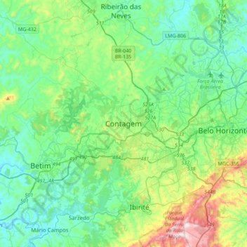
Name: Topografische Karte Contagem, Höhe, Relief.
Durchschnittliche Höhe: 890 m
Minimale Höhe: 711 m
Maximale Höhe: 1.508 m
Spenden
Andere topografische Karten
Klicken Sie auf eine Karte, um ihre Topografie, ihre Höhe und ihr Relief anzuzeigen.
Vila Beneves
Brazil > Minas Gerais > Região Metropolitana de Belo Horizonte > Contagem
Durchschnittliche Höhe: 897 m
Nova Contagem
Brazil > Minas Gerais > Região Metropolitana de Belo Horizonte > Contagem
Durchschnittliche Höhe: 907 m
Parque Industrial
Brazil > Minas Gerais > Região Metropolitana de Belo Horizonte > Contagem
Durchschnittliche Höhe: 942 m