
Spenden
Topografische Karte Lindbergh
Klicken Sie auf die Karte, um die Höhe anzuzeigen.
Spenden
Über diese Karte
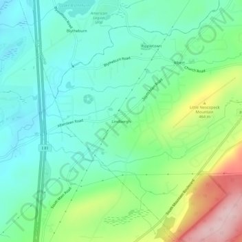
Name: Topografische Karte Lindbergh, Höhe, Relief.
Durchschnittliche Höhe: 386 m
Minimale Höhe: 312 m
Maximale Höhe: 566 m
Spenden
Andere topografische Karten
Klicken Sie auf eine Karte, um ihre Topografie, ihre Höhe und ihr Relief anzuzeigen.
Mountain Top
United States > Pennsylvania > Luzerne County > Wright Township
The elevation within the Mountain Top CDP ranges from 1,070 feet (330 m) above sea level along Big Wapwallopen Creek in the southwest, to 1,860 feet (570 m) atop Nescopeck Mountain southwest of Rita, to 1,871 feet (570 m) at the east end of Penobscot Mountain in the north of the CDP. The central village of…
Durchschnittliche Höhe: 463 m
Mountain Top
United States > Pennsylvania > Luzerne County > Wright Township
The elevation in Mountain Top ranges from 1,070 feet (330 m) above sea level along Big Wapwallopen Creek in the southwest, to 1,860 feet (570 m) atop Nescopeck Mountain southwest of Rita, to 1,871 feet (570 m) at the east end of Penobscot Mountain in north Mountain Top. The central village of Mountain Top sits…
Durchschnittliche Höhe: 463 m
Mountain Top
United States > Pennsylvania > Luzerne County > Wright Township
The elevation within the Mountain Top CDP ranges from 1,070 feet (330 m) above sea level along Big Wapwallopen Creek in the southwest, to 1,860 feet (570 m) atop Nescopeck Mountain southwest of Rita, to 1,871 feet (570 m) at the east end of Penobscot Mountain in the north of the CDP. The central village of…
Durchschnittliche Höhe: 463 m