
Spenden
Topografische Karte Haida Gwaii
Klicken Sie auf die Karte, um die Höhe anzuzeigen.
Spenden
Über diese Karte
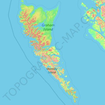
Name: Topografische Karte Haida Gwaii, Höhe, Relief.
Ort: Haida Gwaii, British Columbia, Canada (51.90529 -133.20208 54.26126 -130.93520)
Durchschnittliche Höhe: 37 m
Minimale Höhe: 0 m
Maximale Höhe: 1.042 m
Spenden
Andere topografische Karten
Klicken Sie auf eine Karte, um ihre Topografie, ihre Höhe und ihr Relief anzuzeigen.
Grouse Mountain
Canada > British Columbia > Metro Vancouver Regional District
Grouse Mountain is one of the North Shore Mountains of the Pacific Ranges in the District Municipality of North Vancouver, British Columbia, Canada. With a maximum elevation of over 1,200 m (4,100 feet) at its peak, the mountain is the site of an alpine ski area, Grouse Mountain Resort, which overlooks Greater…
Durchschnittliche Höhe: 968 m
Mount Robson
Canada > British Columbia > Regional District of Fraser-Fort George > Area H (Robson Valley/Canoe)
The north face can be seen from Berg Lake, and reached by a 19 km (11.8 mi) hike. The lake is approximately 2 km long and lies at 1,646 m (5,400 ft) elevation. There are backcountry campgrounds at each end of the lake and a log shelter on its banks, named Hargreaves Shelter in honor of the Hargreaves family…
Durchschnittliche Höhe: 3.042 m
Spenden
Coast Mountains
Canada > British Columbia > Area A (Seymour Inlet/Knight Inlet)
The Coast Mountains are part of the Pacific Ring of Fire—the ring of volcanoes and associated mountains around the Pacific Ocean—and contain some of British Columbia's highest mountains. Mount Waddington is the highest mountain of the Coast Mountains and the highest that lies entirely within British…
Durchschnittliche Höhe: 1.951 m
Whistler
Canada > British Columbia > Squamish-Lillooet Regional District > Whistler Resort Municipality > Whistler
Durchschnittliche Höhe: 996 m
Surrey
Canada > British Columbia > Metro Vancouver Regional District > Surrey
Durchschnittliche Höhe: 65 m
Spenden
Genelle
Canada > British Columbia > Regional District of Kootenay Boundary > Area B (Lower Columbia/Old Glory)
Durchschnittliche Höhe: 656 m
Knouff Lake
Canada > British Columbia > Thompson-Nicola Regional District > Area P (Rivers and the Peaks)
Durchschnittliche Höhe: 1.249 m
Rocky Mountains
Canada > British Columbia > Regional District of East Kootenay > Area A (Upper Flathead/Elk Valley)
Durchschnittliche Höhe: 2.159 m
Spenden
Beaver Lake
Canada > British Columbia > Area E (Moberly Lake/Sukunka Valley)
Durchschnittliche Höhe: 693 m
Cultus Lake
Canada > British Columbia > Fraser Valley Regional District > Area H (Cultus Lake/Columbia Valley) > Cultus Lake
Durchschnittliche Höhe: 191 m
Spenden
Shawnigan Lake
Canada > British Columbia > Cowichan Valley Regional District > Area B (Shawnigan Lake)
Durchschnittliche Höhe: 128 m
Agassiz
Canada > British Columbia > Fraser Valley Regional District > Kent
Durchschnittliche Höhe: 48 m
Rock Creek
Canada > British Columbia > Regional District of Kootenay Boundary > Area E (Beaverdell/West Boundary)
Durchschnittliche Höhe: 764 m
Spenden
70 Mile House
Canada > British Columbia > Thompson-Nicola Regional District > Area E (Bonaparte Plateau)
Durchschnittliche Höhe: 1.087 m
Burnaby
Canada > British Columbia > Metro Vancouver Regional District > Burnaby
Burnaby occupies 98.60 square kilometres (38.07 sq mi) and is located at the geographic centre of the Metro Vancouver area and home to the Metro Vancouver regional government in Metrotown. Situated between the city of Vancouver on the west and Port Moody, Coquitlam, and New Westminster on the east, Burnaby is…
Durchschnittliche Höhe: 144 m
Richmond
Canada > British Columbia > Metro Vancouver Regional District > Richmond
Durchschnittliche Höhe: 15 m
Spenden
Armstrong
Canada > British Columbia > Regional District of North Okanagan > Armstrong > Armstrong
Durchschnittliche Höhe: 494 m
Ainsworth Hot Springs
Canada > British Columbia > Regional District of Central Kootenay > Area D (Lardeau Valley/Duncan Lake)
Durchschnittliche Höhe: 741 m
Japan Gulch Reservoir
Canada > British Columbia > Capital Regional District > Juan de Fuca Electoral Area
Durchschnittliche Höhe: 274 m
Cherryville
Canada > British Columbia > Regional District of North Okanagan > Area E (Cherryville/East Creighton)
Durchschnittliche Höhe: 643 m
Spenden
Bouchie Lake
Canada > British Columbia > Cariboo Regional District > Area B (Quesnel West/Bouchie Lake)
Durchschnittliche Höhe: 699 m
Spenden
Spenden
Pavilion
The early anglicized version of the village name was Skwailuk, meaning hoar-frost, perhaps indicating the shaded ground remaining frozen during the long winters at this elevation. The Ts'kw'aylaxw First Nation (a.k.a. the Tsk'waylacw First Nation or Tsk'weylecw First Nation), residing on the Pavilion 1 Indian…
Durchschnittliche Höhe: 855 m
Spenden
Queen Elizabeth Park
Canada > British Columbia > Metro Vancouver Regional District > Vancouver
Durchschnittliche Höhe: 81 m
Spenden
Kamloops
Canada > British Columbia > Thompson-Nicola Regional District > Kamloops
Durchschnittliche Höhe: 875 m
Spenden
Davis Lake Recreation Site
Canada > British Columbia > Thompson-Nicola Regional District > Area N (Beautiful Nicola Valley - South)
Durchschnittliche Höhe: 1.123 m
Spenden
Spillimacheen
Canada > British Columbia > Regional District of East Kootenay > Area G (Forster Creek/Mount Assiniboine)
Durchschnittliche Höhe: 971 m
Cooper Creek
Canada > British Columbia > Regional District of Central Kootenay > Area D (Lardeau Valley/Duncan Lake)
Durchschnittliche Höhe: 1.573 m
Lac La Hache
Canada > British Columbia > Cariboo Regional District > Area G (Lac La Hache/108 Mile Ranch)
Durchschnittliche Höhe: 847 m
Fort Nelson
Canada > British Columbia > Northern Rockies Regional Municipality
Durchschnittliche Höhe: 405 m
Spenden
Britannia Beach
Canada > British Columbia > Squamish-Lillooet Regional District > Area D (Elaho/Garibaldi)
Durchschnittliche Höhe: 208 m
Fort Steele
Canada > British Columbia > Regional District of East Kootenay > Area C (Moyie/Bull River)
Durchschnittliche Höhe: 797 m
Lone Butte
Canada > British Columbia > Cariboo Regional District > Area L (Lone Butte/Interlakes)
The northward advance of the Pacific Great Eastern Railway (PGE) rail head passed through Lone Butte in late April 1919. This construction camp had a large kitchen employing 25 cooks, of whom two received the Distinguished Conduct Medal and three the Military Medal during World War I. At an elevation of about…
Durchschnittliche Höhe: 1.159 m
150 Mile House
Canada > British Columbia > Cariboo Regional District > Area F (Horsefly/Likely/150 Mile House)
Durchschnittliche Höhe: 789 m
Spenden
Ernest Lake
Canada > British Columbia > Thompson-Nicola Regional District > Area L (Grasslands)
Durchschnittliche Höhe: 1.260 m
Whiteswan Lake
Canada > British Columbia > Regional District of East Kootenay > Area F (Columbia Lake/Windermere Lake)
Durchschnittliche Höhe: 1.392 m
Bralorne
Canada > British Columbia > Squamish-Lillooet Regional District > Area A (Upper Bridge River Valley)
Durchschnittliche Höhe: 1.255 m
Spenden
Sun Peaks
Canada > British Columbia > Thompson-Nicola Regional District > Sun Peaks Mountain Resort Municipality
Durchschnittliche Höhe: 1.490 m
Vancouver Island Ranges
Canada > British Columbia > Area D (Oyster Bay/Buttle Lake)
Durchschnittliche Höhe: 863 m
Cultus Lake
Canada > British Columbia > Thompson-Nicola Regional District > Area J (Copper Desert Country)
Durchschnittliche Höhe: 1.033 m
Spenden
Saanich
Canada > British Columbia > Capital Regional District > Saanich > Saanich
Durchschnittliche Höhe: 32 m
Whistler Village
Canada > British Columbia > Squamish-Lillooet Regional District > Whistler
Durchschnittliche Höhe: 775 m
Montney
Canada > British Columbia > Peace River Regional District > Area B (Finlay Valley/Beatton Valley)
It lies at an elevation of 700 meters (2,300 ft), along the BC Rail tracks.
Durchschnittliche Höhe: 718 m
Spenden
Andy Livingstone Park
Canada > British Columbia > Metro Vancouver Regional District > Vancouver
Durchschnittliche Höhe: 12 m
Mount Begbie
Canada > British Columbia > Columbia-Shuswap Regional District > Area B (Shelter Bay/Mica Creek)
Durchschnittliche Höhe: 2.066 m
Lac Le Jeune
Canada > British Columbia > Thompson-Nicola Regional District > Area J (Copper Desert Country)
Durchschnittliche Höhe: 1.309 m
Loon Lake
Canada > British Columbia > Regional District of North Okanagan > Area D (Trinity/West Creighton)
Durchschnittliche Höhe: 1.360 m
Spenden
Mount Strachan
Canada > British Columbia > Regional District of East Kootenay > Area A (Upper Flathead/Elk Valley)
Durchschnittliche Höhe: 2.198 m
Skeena Mountains
Canada > British Columbia > Regional District of Bulkley-Nechako > Area C (Stuart Lake/Omineca Valley)
Durchschnittliche Höhe: 1.339 m
Cassiar Mountains
Canada > British Columbia > Peace River Regional District > Area B (Finlay Valley/Beatton Valley)
Durchschnittliche Höhe: 935 m
Spenden
Mill Bay
Canada > British Columbia > Cowichan Valley Regional District > Area A (Mill Bay / Malahat)
Durchschnittliche Höhe: 61 m
Woss
Canada > British Columbia > Regional District of Mount Waddington > Area D (Nimpkish Valley/Cormorant Island)
Durchschnittliche Höhe: 200 m
Oyster River
Canada > British Columbia > Strathcona Regional District > Area D (Oyster Bay/Buttle Lake) > Oyster River
Durchschnittliche Höhe: 24 m
Shuswap
Canada > British Columbia > Regional District of East Kootenay > Area F (Columbia Lake/Windermere Lake)
Durchschnittliche Höhe: 926 m
Spenden
Gabriola
Canada > British Columbia > Regional District of Nanaimo > Area B (DeCourcy/Gabriola/Mudge)
Gabriola is about 14 kilometres (9 mi) long by 4.2 kilometres (2.6 mi) wide on average with a land area of 57.6 square kilometres (22.2 sq mi). The topography varies from flat sandy beaches at sea level to forested hills rising to 160 metres (525 ft) on Stoney Ridge in the centre of the island.
Durchschnittliche Höhe: 31 m
Errington
Canada > British Columbia > Regional District of Nanaimo > Area F (Alberni Highway)
Durchschnittliche Höhe: 120 m
The Commons Field
Canada > British Columbia > Regional District of Central Okanagan > Kelowna
Durchschnittliche Höhe: 442 m
Woodlot 0007
Canada > British Columbia > Metro Vancouver Regional District > Maple Ridge
Durchschnittliche Höhe: 322 m
Spenden
Agur Lake
Canada > British Columbia > Regional District of Okanagan-Similkameen > Area F (Trout Creek Valley)
Durchschnittliche Höhe: 1.178 m
Faulder
Canada > British Columbia > Regional District of Okanagan-Similkameen > Area F (Trout Creek Valley)
Durchschnittliche Höhe: 850 m
Crooked River
Canada > British Columbia > Regional District of Fraser-Fort George > Area G (Crooked River/Parsnip)
Durchschnittliche Höhe: 749 m
Carp Lake
Canada > British Columbia > Regional District of Fraser-Fort George > Area G (Crooked River/Parsnip)
Durchschnittliche Höhe: 865 m
Spenden
Pine River
Canada > British Columbia > Peace River Regional District > Area E (Moberly Lake/Sukunka Valley)
Durchschnittliche Höhe: 973 m
Parkland
Canada > British Columbia > Peace River Regional District > Area D (Kiskatinaw Valley)
Durchschnittliche Höhe: 726 m
Walnut Park
Canada > British Columbia > Metro Vancouver Regional District > Surrey
Durchschnittliche Höhe: 49 m
Spenden
Mount Tabor
Canada > British Columbia > Regional District of Fraser-Fort George > Area D (Tabor Lake/Stone Creek)
Durchschnittliche Höhe: 1.119 m
Cottonwood River
Canada > British Columbia > Cariboo Regional District > Area C (Bowron Lake/Barlow Creek/Barkerville)
Durchschnittliche Höhe: 799 m
Scotch Creek
Canada > British Columbia > Columbia-Shuswap Regional District > Area F (Scotch Creek/Seymour Arm)
Durchschnittliche Höhe: 1.125 m
Harrison River
Canada > British Columbia > Fraser Valley Regional District > Kent > Harrison Mills
Durchschnittliche Höhe: 45 m
Spenden