Geolokalisieren
👉 Easily get elevation data in JSON, GeoTIFF and KML formats using Elevation API
Vielen Dank für die Unterstützung dieser Website ❤️
Spenden

Topografische Karte Karur

Klicken Sie auf die Karte, um die Höhe anzuzeigen.

👉 Easily get elevation data in JSON, GeoTIFF and KML formats using Elevation API
Vielen Dank für die Unterstützung dieser Website ❤️
Spenden

Karur

Karur is located at 10°57′36″N 78°04′30″E / 10.960°N 78.075°E / 10.960; 78.075 and has an average elevation of 101 metres or 331 feet. The town is located in Karur district, at a distance of 370 km (230 mi) from Chennai. The town is located on the banks of the rivers Amaravathi, Kaveri and Noyyal with a plain topography. There are no notable mineral resources available in and around the town. The soil types are black and red that are conducive for common crops in the Cauvery delta.

Wikipedia (CC-BY-SA 3.0)

👉 Easily get elevation data in JSON, GeoTIFF and KML formats using Elevation API
Vielen Dank für die Unterstützung dieser Website ❤️
Spenden

Über diese Karte

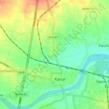
Name: Topografische Karte Karur, Höhe, Relief.

Ort: Karur, Tamil Nadu, India (10.92235 78.02884 11.00011 78.11689)

Durchschnittliche Höhe: 129 m

Minimale Höhe: 106 m

Maximale Höhe: 161 m

👉 Easily get elevation data in JSON, GeoTIFF and KML formats using Elevation API
Vielen Dank für die Unterstützung dieser Website ❤️
Spenden

Andere topografische Karten

Klicken Sie auf eine Karte, um ihre Topografie, ihre Höhe und ihr Relief anzuzeigen.

Puliyur

India > Tamil Nadu > Karur

Durchschnittliche Höhe: 116 m

Vangal

India > Tamil Nadu > Karur

Durchschnittliche Höhe: 122 m

Thalavapalayam

India > Tamil Nadu > Karur

Durchschnittliche Höhe: 126 m

Periyar nagar

India > Tamil Nadu > Karur

Durchschnittliche Höhe: 148 m

Vielen Dank für die Unterstützung dieser Website ❤️
Spenden

Nanjai Pugalur

India > Tamil Nadu > Karur

Durchschnittliche Höhe: 155 m

Velayuthampalayam

India > Tamil Nadu > Karur

Durchschnittliche Höhe: 138 m

Pugalur

India > Tamil Nadu > Karur

Durchschnittliche Höhe: 134 m