
Topografische Karte Farlam
Klicken Sie auf die Karte, um die Höhe anzuzeigen.
Farlam
Farlam was originally divided into two townships, East Farlam and West Farlam, with a combined population in 1811 of 672 inhabitants and 115 houses. Hallbankgate and Kirkhouse were two hamlets located within the township of East Farlam, the former four miles south east of Brampton, and the latter, where the church stands, half-a-mile east of the village. Milton was a small village in West Farlam and is now in Brampton parish. The whole parish has a high elevation and topographically is quite hilly with an area in 1847 of 5,680 acres.
Über diese Karte
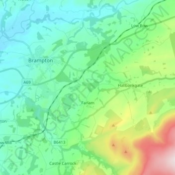
Name: Topografische Karte Farlam, Höhe, Relief.
Ort: Farlam, Carlisle, Cumbria, England, United Kingdom (54.90964 -2.71009 54.94788 -2.56018)
Durchschnittliche Höhe: 167 m
Minimale Höhe: 28 m
Maximale Höhe: 611 m
Andere topografische Karten
Klicken Sie auf eine Karte, um ihre Topografie, ihre Höhe und ihr Relief anzuzeigen.
Trundley Wood
United Kingdom > England > Cumbria > Carlisle > Hethersgill
Durchschnittliche Höhe: 51 m