
Spenden
Topografische Karte Rocky Mountains
Klicken Sie auf die Karte, um die Höhe anzuzeigen.
Spenden
Über diese Karte
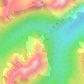
Name: Topografische Karte Rocky Mountains, Höhe, Relief.
Durchschnittliche Höhe: 2.159 m
Minimale Höhe: 1.823 m
Maximale Höhe: 2.591 m
Spenden
Andere topografische Karten
Klicken Sie auf eine Karte, um ihre Topografie, ihre Höhe und ihr Relief anzuzeigen.
Upper Elk Lake
Canada > British Columbia > Regional District of East Kootenay > Area A (Upper Flathead/Elk Valley)
Durchschnittliche Höhe: 1.982 m
Mount Fernie Provincial Park
Canada > British Columbia > Regional District of East Kootenay > Area A (Upper Flathead/Elk Valley)
Durchschnittliche Höhe: 1.108 m
Morrissey Provincial Park
Canada > British Columbia > Regional District of East Kootenay > Area A (Upper Flathead/Elk Valley)
Durchschnittliche Höhe: 1.040 m
Barnes Lake
Canada > British Columbia > Regional District of East Kootenay > Area A (Upper Flathead/Elk Valley)
Durchschnittliche Höhe: 2.073 m
Spenden
Grave Lake
Canada > British Columbia > Regional District of East Kootenay > Area A (Upper Flathead/Elk Valley)
Durchschnittliche Höhe: 1.426 m
Island Lake
Canada > British Columbia > Regional District of East Kootenay > Area A (Upper Flathead/Elk Valley)
Durchschnittliche Höhe: 1.511 m