
Topografische Karte Dickie Lake
Interaktive Karte
Klicken Sie auf die Karte, um die Höhe anzuzeigen.
Über diese Karte
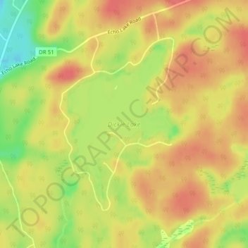
Name: Topografische Karte Dickie Lake, Höhe, Relief.
Durchschnittliche Höhe: 360 m
Minimale Höhe: 320 m
Maximale Höhe: 383 m
Andere topografische Karten
Klicken Sie auf eine Karte, um ihre Topografie, ihre Höhe und ihr Relief anzuzeigen.
Ril Lake
Canada > Ontario > Lake of Bays Township > Lake of Bays
Ril Lake, South Ril Lake Road, Lake of Bays Township, District Municipality of Muskoka, Muskoka District, Central Ontario, Ontario, Canada
Durchschnittliche Höhe: 361 m
Grant Lake
Canada > Ontario > Lake of Bays
Grant Lake, Shoe Lake Road, Lake of Bays, District Municipality of Muskoka, Muskoka District, Ontario, P0A 1E0, Canada
Durchschnittliche Höhe: 384 m
Cream Lake
Canada > Ontario > Lake of Bays
Cream Lake, South Ril Lake Road, Lake of Bays, District Municipality of Muskoka, Muskoka District, Ontario, Canada
Durchschnittliche Höhe: 363 m
Menominee Lake
Canada > Ontario > Lake of Bays
Menominee Lake, Grand Boulevard, Lake of Bays, District Municipality of Muskoka, Muskoka District, Ontario, Canada
Durchschnittliche Höhe: 355 m
Dotty Lake
Canada > Ontario > Lake of Bays
Dotty Lake, Brookes Road, Lake of Bays, District Municipality of Muskoka, Muskoka District, Ontario, Canada
Durchschnittliche Höhe: 403 m
Porcupine Lake
Canada > Ontario > Lake of Bays
Porcupine Lake, South Ril Lake Road, Lake of Bays, District Municipality of Muskoka, Muskoka District, Ontario, Canada
Durchschnittliche Höhe: 361 m