
Spenden
Topografische Karte Udyavara
Klicken Sie auf die Karte, um die Höhe anzuzeigen.
Spenden
Über diese Karte
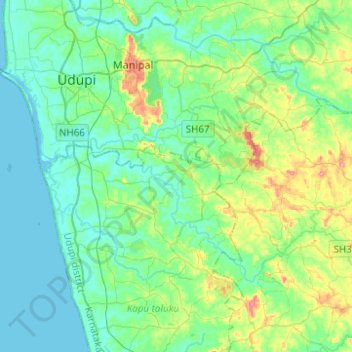
Name: Topografische Karte Udyavara, Höhe, Relief.
Durchschnittliche Höhe: 30 m
Minimale Höhe: -4 m
Maximale Höhe: 136 m
Spenden
Andere topografische Karten
Klicken Sie auf eine Karte, um ihre Topografie, ihre Höhe und ihr Relief anzuzeigen.
Manipal
India > Karnataka > Udupi taluku
Manipal is a suburb and university town within Udupi, in coastal Karnataka, India. Manipal is located five kilometres away from the centre of Udupi City, in Udupi District, Karnataka (state) in south western India. It is administered by the Udupi City Municipality. The suburb is located in coastal Karnataka,…
Durchschnittliche Höhe: 32 m
Udupi
India > Karnataka > Udupi taluku
Udupi has an elevation of 27 m (89 ft) above mean sea level. The climate in Udupi is hot in summers and pleasant in winter. During summers (from March to May) the temperature reaches up to 38 °C (100 °F) and in winters (from December to February) it is usually between 32 and 20 °C (90 and 68 °F). As it is…
Durchschnittliche Höhe: 17 m
Spenden
Spenden
Bramhavara Akashavani
India > Karnataka > Udupi taluku > Brahmavara > Bramhavara Akashavani
Durchschnittliche Höhe: 14 m
Manipal
India > Karnataka > Udupi taluku
Manipal (Kannada: [mɐɳipaːlɐ]) is a suburb and university town within Udupi, in coastal Karnataka, India. Manipal is located five kilometres away from the centre of Udupi City, in Udupi District, Karnataka (state) in south western India. It is administered by the Udupi City Municipality. The suburb is…
Durchschnittliche Höhe: 32 m
Spenden