
Topografische Karte Abha
Interaktive Karte
Klicken Sie auf die Karte, um die Höhe anzuzeigen.
Abha
Abha is located in the southern region of Asir at an elevation of about 2,270 metres (7,450 feet) above sea level. Abha lies on the western edge of Mount Al-Hijaz, near Jabal Sawda, the highest peak in Saudi Arabia. Treating the Asir Mountains as part of the Sarawat, the landscape is otherwise dominated by the Sarawat Mountains.
Über diese Karte
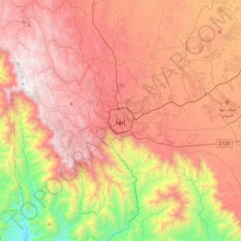
Name: Topografische Karte Abha, Höhe, Relief.
Ort: Abha, 'Asir Province, 26442, Saudi Arabia (18.05643 42.34436 18.37643 42.66436)
Durchschnittliche Höhe: 1.994 m
Minimale Höhe: 722 m
Maximale Höhe: 2.991 m