
Topografische Karte Deep Ford
Interaktive Karte
Klicken Sie auf die Karte, um die Höhe anzuzeigen.
Über diese Karte
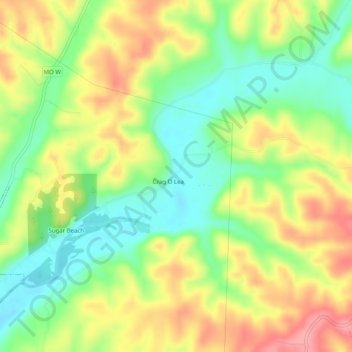
Name: Topografische Karte Deep Ford, Höhe, Relief.
Ort: Deep Ford, McDonald County, Missouri, 64856, United States (36.58979 -94.37132 36.62979 -94.33132)
Durchschnittliche Höhe: 308 m
Minimale Höhe: 258 m
Maximale Höhe: 367 m
Andere topografische Karten
Klicken Sie auf eine Karte, um ihre Topografie, ihre Höhe und ihr Relief anzuzeigen.
Jane
United States > Missouri > McDonald County
Jane, McDonald County, Missouri, United States
Durchschnittliche Höhe: 321 m
Powell
United States > Missouri > McDonald County
Powell, McDonald County, Missouri, 65730, United States
Durchschnittliche Höhe: 341 m
Noel
United States > Missouri > McDonald County
Noel, McDonald County, Missouri, 64854, United States
Durchschnittliche Höhe: 287 m
Rocky Comfort
United States > Missouri > McDonald County
Rocky Comfort, McDonald County, Missouri, 64861, United States
Durchschnittliche Höhe: 401 m
Lanagan
United States > Missouri > McDonald County
Lanagan, McDonald County, Missouri, 64847, United States
Durchschnittliche Höhe: 294 m
Pineville
United States > Missouri > McDonald County
Pineville, McDonald County, Missouri, 64556, United States
Durchschnittliche Höhe: 314 m
Noel
United States > Missouri > McDonald County
Noel, McDonald County, Missouri, 64854, United States
Durchschnittliche Höhe: 287 m
Goodman
United States > Missouri > McDonald County
Goodman, McDonald County, Missouri, United States
Durchschnittliche Höhe: 372 m