
Topografische Karte Fanning
Interaktive Karte
Klicken Sie auf die Karte, um die Höhe anzuzeigen.
Über diese Karte
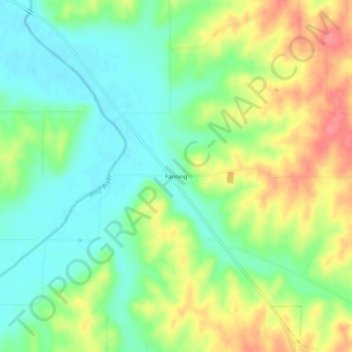
Name: Topografische Karte Fanning, Höhe, Relief.
Ort: Fanning, Doniphan County, Kansas, United States (39.81472 -95.18136 39.85472 -95.14136)
Durchschnittliche Höhe: 291 m
Minimale Höhe: 259 m
Maximale Höhe: 338 m
Andere topografische Karten
Klicken Sie auf eine Karte, um ihre Topografie, ihre Höhe und ihr Relief anzuzeigen.
Bendena
United States > Kansas > Doniphan County
Bendena, Doniphan County, Kansas, 66008, United States
Durchschnittliche Höhe: 328 m
Elwood
United States > Kansas > Doniphan County
Elwood, Doniphan County, Kansas, 66024, United States
Durchschnittliche Höhe: 257 m
Wathena
United States > Kansas > Doniphan County
Wathena, Doniphan County, Kansas, 66090, United States
Durchschnittliche Höhe: 266 m
Leona
United States > Kansas > Doniphan County
Leona, Doniphan County, Kansas, United States
Durchschnittliche Höhe: 293 m
Severance
United States > Kansas > Doniphan County
Severance, Doniphan County, Kansas, United States
Durchschnittliche Höhe: 291 m
Denton
United States > Kansas > Doniphan County
Denton, Doniphan County, Kansas, United States
Durchschnittliche Höhe: 319 m
Troy
United States > Kansas > Doniphan County
Troy, Doniphan County, Kansas, United States
Durchschnittliche Höhe: 331 m
White Cloud
United States > Kansas > Doniphan County
White Cloud, Doniphan County, Kansas, United States
Durchschnittliche Höhe: 285 m
Highland
United States > Kansas > Doniphan County
Highland, Doniphan County, Kansas, 66035, United States
Durchschnittliche Höhe: 315 m