
Topografische Karte Berkshire County
Interaktive Karte
Klicken Sie auf die Karte, um die Höhe anzuzeigen.
Über diese Karte
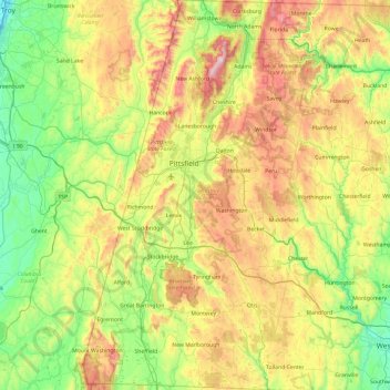
Name: Topografische Karte Berkshire County, Höhe, Relief.
Ort: Berkshire County, Massachusetts, United States of America (42.03982 -73.50814 42.74585 -72.94944)
Durchschnittliche Höhe: 359 m
Minimale Höhe: 2 m
Maximale Höhe: 1.061 m
Running north-south through the county are the Hoosac Range of the Berkshire Hills in the eastern part of the county and the Taconic Mountains in the western part of the county. Due to their elevation, the Berkshires attract tourists and summer residents eager to escape the heat of the lowlands.