
Spenden
Topografische Karte मनाङ
Klicken Sie auf die Karte, um die Höhe anzuzeigen.
Spenden
मनाङ
Der 2246 km² große Distrikt liegt direkt an der chinesischen Grenze im Zentralhimalaya. Seine Distriktnachbarn sind: Kaski, Lamjung, Gorkha, Mustang und Myagdi. Die Topografie wird bestimmt durch den Marsyangdi-Fluss, der am 5413 m hohen Thorong La entspringt. Dieser Pass bildet auch einen Übergang zum Distrikt Mustang nach Muktinath.
Spenden
Über diese Karte
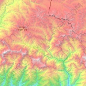
Name: Topografische Karte मनाङ, Höhe, Relief.
Ort: मनाङ, Provinz Gandaki, 33500, Nepal (28.44496 83.78724 28.90057 84.57149)
Durchschnittliche Höhe: 4.547 m
Minimale Höhe: 1.108 m
Maximale Höhe: 8.034 m
Spenden
Andere topografische Karten
Klicken Sie auf eine Karte, um ihre Topografie, ihre Höhe und ihr Relief anzuzeigen.
Spenden
Spenden
मनास्लु
Nepal > Provinz Gandaki > Gorkha
Der Manaslu (nepali: मनास्लु Manāslu) in Nepal ist einer der vierzehn Achttausender, mit einer Höhe von 8163 m ist er der achthöchste Berg der Erde.
Durchschnittliche Höhe: 7.069 m