
Topografische Karte Lago de Izabal
Interaktive Karte
Klicken Sie auf die Karte, um die Höhe anzuzeigen.
Über diese Karte
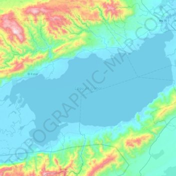
Name: Topografische Karte Lago de Izabal, Höhe, Relief.
Ort: Lago de Izabal, El Estor, Izabal, Guatemala (15.35740 -89.41921 15.63763 -88.98093)
Durchschnittliche Höhe: 184 m
Minimale Höhe: -1 m
Maximale Höhe: 1.171 m
Andere topografische Karten
Klicken Sie auf eine Karte, um ihre Topografie, ihre Höhe und ihr Relief anzuzeigen.
Patzun
Guatemala > Izabal > Los Amates
Patzun, Los Amates, Izabal, Guatemala
Durchschnittliche Höhe: 53 m
Mariscos
Guatemala > Izabal > Los Amates
Mariscos, Los Amates, Izabal, Guatemala
Durchschnittliche Höhe: 29 m
Chiriqui
Guatemala > Izabal > Los Amates > Chiriqui
Chiriqui, Los Amates, Izabal, Guatemala
Durchschnittliche Höhe: 51 m
Puerto Barrios
Guatemala > Izabal > Puerto Barrios
Puerto Barrios, Izabal, 18013, Guatemala
Durchschnittliche Höhe: 92 m
Santo Tomás De Castilla
Guatemala > Izabal > Santo Tomás De Castilla
Santo Tomás De Castilla, Puerto Barrios, Izabal, 18013, Guatemala
Durchschnittliche Höhe: 72 m
Los Amates
Guatemala > Izabal > Los Amates > Los Amates
Los Amates, Izabal, Guatemala
Durchschnittliche Höhe: 114 m
Río Motagua
Río Motagua, Puerto Barrios, Izabal, Guatemala
Durchschnittliche Höhe: 3 m
Río Escondido
Guatemala > Izabal > Puerto Barrios
Río Escondido, Puerto Barrios, Izabal, 18013, Guatemala
Durchschnittliche Höhe: 12 m
Biotopo Chocón-Machacas
Biotopo Chocón-Machacas, Livingston, Izabal, Guatemala
Durchschnittliche Höhe: 19 m
La Esmeralda
Guatemala > Izabal > La Esmeralda
La Esmeralda, Livingston, Izabal, 18002, Guatemala
Durchschnittliche Höhe: 8 m
Laguneta El Amatillo
Laguneta El Amatillo, El Estor, Izabal, Guatemala
Durchschnittliche Höhe: 3 m
Balastrera Semox
Guatemala > Izabal > Balastrera Semox
Balastrera Semox, Livingston, Izabal, Guatemala
Durchschnittliche Höhe: 59 m