
Topografische Karte Tillamook County
Interaktive Karte
Klicken Sie auf die Karte, um die Höhe anzuzeigen.
Über diese Karte
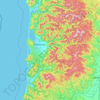
Name: Topografische Karte Tillamook County, Höhe, Relief.
Ort: Tillamook County, Oregon, United States of America (45.04442 -124.09575 45.78360 -123.29927)
Durchschnittliche Höhe: 236 m
Minimale Höhe: -3 m
Maximale Höhe: 1.073 m
According to the U.S. Census Bureau, the county has a total area of 1,333 square miles (3,450 km2), of which 1,103 square miles (2,860 km2) is land and 230 square miles (600 km2) (17%) is water. At 3,706 feet (1130 m) in elevation, Rogers Peak is the highest point in the county and the highest in the Northern Oregon Coast Range.
Andere topografische Karten
Klicken Sie auf eine Karte, um ihre Topografie, ihre Höhe und ihr Relief anzuzeigen.
Hillsboro
United States of America > Oregon > Hillsboro
Hillsboro, Washington County, Oregon, United States of America
Durchschnittliche Höhe: 53 m
Clackamas County
United States of America > Oregon
Clackamas County, Oregon, United States of America
Durchschnittliche Höhe: 660 m
Multnomah County
United States of America > Oregon
Multnomah County, Oregon, United States of America
Durchschnittliche Höhe: 334 m
Coos County
United States of America > Oregon
Coos County, Oregon, United States of America
Durchschnittliche Höhe: 266 m