
Vielen Dank für die Unterstützung dieser Website ❤️
Spenden
Spenden
Topografische Karte IHDP Colony(2)
Klicken Sie auf die Karte, um die Höhe anzuzeigen.
Vielen Dank für die Unterstützung dieser Website ❤️
Spenden
Spenden
Über diese Karte
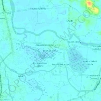
Name: Topografische Karte IHDP Colony(2), Höhe, Relief.
Ort: IHDP Colony(2), Vaikom, Kottayam, Kerala, 686608, India (9.77200 76.39526 9.81200 76.43526)
Durchschnittliche Höhe: 4 m
Minimale Höhe: -1 m
Maximale Höhe: 36 m
Vielen Dank für die Unterstützung dieser Website ❤️
Spenden
Spenden
Andere topografische Karten
Klicken Sie auf eine Karte, um ihre Topografie, ihre Höhe und ihr Relief anzuzeigen.
Vielen Dank für die Unterstützung dieser Website ❤️
Spenden
Spenden
Arakkulam
India > Kerala > Vaikom > Thalayolaparambu > Chundangakari vadachira colony
Durchschnittliche Höhe: 6 m