
Vielen Dank für die Unterstützung dieser Website ❤️
Spenden
Spenden
Topografische Karte Villa Cordopatri
Klicken Sie auf die Karte, um die Höhe anzuzeigen.
Vielen Dank für die Unterstützung dieser Website ❤️
Spenden
Spenden
Villa Cordopatri
La frazione è situata in un'area prevalentemente pianeggiante, con un'altitudine di circa 73 metri sul livello del mare. Il territorio è caratterizzato da terreni agricoli e spazi rurali.
Vielen Dank für die Unterstützung dieser Website ❤️
Spenden
Spenden
Über diese Karte
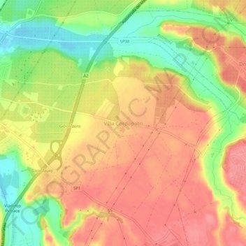
Name: Topografische Karte Villa Cordopatri, Höhe, Relief.
Durchschnittliche Höhe: 56 m
Minimale Höhe: 7 m
Maximale Höhe: 89 m
Vielen Dank für die Unterstützung dieser Website ❤️
Spenden
Spenden