
Topografische Karte Rabbitville
Interaktive Karte
Klicken Sie auf die Karte, um die Höhe anzuzeigen.
Über diese Karte
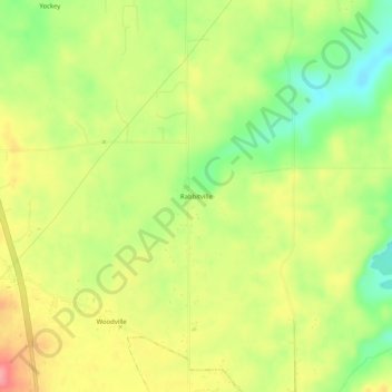
Name: Topografische Karte Rabbitville, Höhe, Relief.
Ort: Rabbitville, Lawrence County, Indiana, 47446, United States (38.74866 -86.49388 38.78866 -86.45388)
Durchschnittliche Höhe: 196 m
Minimale Höhe: 148 m
Maximale Höhe: 243 m
Andere topografische Karten
Klicken Sie auf eine Karte, um ihre Topografie, ihre Höhe und ihr Relief anzuzeigen.
Otis Park
United States > Indiana > Lawrence County > Bedford
Otis Park, Bedford, Lawrence County, Indiana, United States
Durchschnittliche Höhe: 186 m
Bedford
United States > Indiana > Lawrence County
Bedford, Lawrence County, Indiana, 47421, United States
Durchschnittliche Höhe: 191 m
Crawford
United States > Indiana > Lawrence County > Crawford
Crawford, Lawrence County, Indiana, United States
Durchschnittliche Höhe: 198 m
Springville
United States > Indiana > Lawrence County > Springville
Springville, Lawrence County, Indiana, United States
Durchschnittliche Höhe: 219 m
Mitchell
United States > Indiana > Lawrence County
Mitchell, Lawrence County, Indiana, 47446, United States
Durchschnittliche Höhe: 209 m