
Vielen Dank für die Unterstützung dieser Website ❤️
Spenden
Spenden
Topografische Karte Kaduru
Klicken Sie auf die Karte, um die Höhe anzuzeigen.
Vielen Dank für die Unterstützung dieser Website ❤️
Spenden
Spenden
Kaduru
Kadur is located in the eastern part of Chikmagalur district, which has a semi-arid climate. Its elevation is around 760 metres above the mean sea level. It has a dry climate with annual rainfall less than 750 millimetres (30 in).
Vielen Dank für die Unterstützung dieser Website ❤️
Spenden
Spenden
Über diese Karte
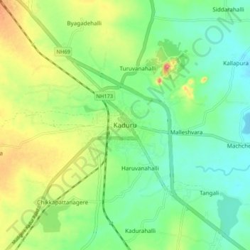
Name: Topografische Karte Kaduru, Höhe, Relief.
Ort: Kaduru, Kaduru taluk, Chikkamagaluru, Karnataka, 577548, India (13.51275 75.97424 13.59275 76.05424)
Durchschnittliche Höhe: 765 m
Minimale Höhe: 733 m
Maximale Höhe: 822 m
Vielen Dank für die Unterstützung dieser Website ❤️
Spenden
Spenden