
Topografische Karte Sevogle
Interaktive Karte
Klicken Sie auf die Karte, um die Höhe anzuzeigen.
Über diese Karte
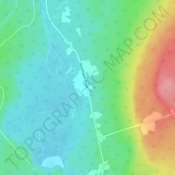
Name: Topografische Karte Sevogle, Höhe, Relief.
Durchschnittliche Höhe: 46 m
Minimale Höhe: 12 m
Maximale Höhe: 124 m
Andere topografische Karten
Klicken Sie auf eine Karte, um ihre Topografie, ihre Höhe und ihr Relief anzuzeigen.
Wayerton
Canada > New Brunswick > Northesk Parish
Wayerton, Northesk Parish, Northumberland County, New Brunswick, Canada
Durchschnittliche Höhe: 46 m
Sunny Corner
Canada > New Brunswick > Northesk Parish
Sunny Corner, Northesk Parish, Northumberland County, New Brunswick, E9E 1J1, Canada
Durchschnittliche Höhe: 28 m
Northwest Miramachi River
Canada > New Brunswick > Northesk Parish
Northwest Miramachi River, Northesk Parish, Northumberland County, New Brunswick, Canada
Durchschnittliche Höhe: 214 m
Northesk
Canada > New Brunswick > Northesk Parish
Northesk, Northesk Parish, Northumberland County, New Brunswick, Canada
Durchschnittliche Höhe: 402 m