
Spenden
Topografische Karte Nizampur
Klicken Sie auf die Karte, um die Höhe anzuzeigen.
Spenden
Über diese Karte
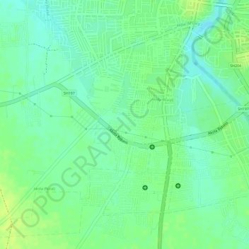
Name: Topografische Karte Nizampur, Höhe, Relief.
Ort: Nizampur, Akola, Maharashtra, India (20.68997 76.97739 20.70041 76.98524)
Durchschnittliche Höhe: 280 m
Minimale Höhe: 271 m
Maximale Höhe: 287 m
Spenden
Andere topografische Karten
Klicken Sie auf eine Karte, um ihre Topografie, ihre Höhe und ihr Relief anzuzeigen.
Kalasubai peak
India > Maharashtra > Akola
Kalsubai (Marathi: कळसूबाई शिखर) is a mountain in the Western Ghats, located in the Indian state of Maharashtra. Its summit, situated at an elevation of 1,646 metres (5,400 ft), is the highest point in Maharashtra.
Durchschnittliche Höhe: 1.210 m
Spenden
Spenden
Spenden
Akole
India > Maharashtra > Akola
Kalsubai is the highest peak in Maharashtra, with an elevation of 1,646 meters (5,400 feet). Ghatghar, located 22 kilometers (14 miles) from Bhandardara, offers views of the Sahyadri range and is the site of the Udanchan Hydro-power project's first installation, which has a capacity of 250 MW. Additionally,…
Durchschnittliche Höhe: 749 m
Spenden
Kalasubai peak
India > Maharashtra > Akola
Kalsubai (Marathi: कळसूबाई शिखर) is a mountain in the Western Ghats, located in the Indian state of Maharashtra. Its summit, situated at an elevation of 1,646 metres (5,400 ft), is the highest point in Maharashtra.
Durchschnittliche Höhe: 1.210 m