
Spenden
Topografische Karte Pooyamkutty
Klicken Sie auf die Karte, um die Höhe anzuzeigen.
Spenden
Über diese Karte
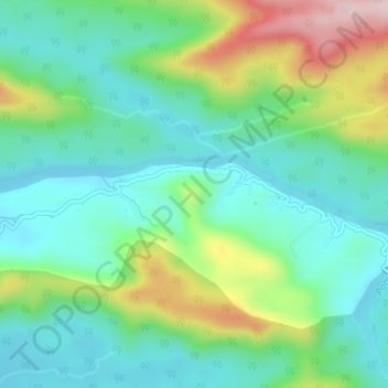
Name: Topografische Karte Pooyamkutty, Höhe, Relief.
Ort: Pooyamkutty, Kothamangalam, Ernakulam District, Kerala, India (10.16351 76.74943 10.17017 76.78710)
Durchschnittliche Höhe: 129 m
Minimale Höhe: 35 m
Maximale Höhe: 356 m
Spenden
Andere topografische Karten
Klicken Sie auf eine Karte, um ihre Topografie, ihre Höhe und ihr Relief anzuzeigen.
Kothamangalam
India > Kerala > Kothamangalam
Kothamangalam is situated in the eastern part of the Ernakulam district. According to the division of the geographical regions of Kerala, Kothamangalam is in a mid-land region. The general topography is hilly.
Durchschnittliche Höhe: 34 m
Spenden
Spenden
Spenden
Edalipparakudy Tribal Settlement, Edamalakudy
India > Kerala > Kothamangalam
Durchschnittliche Höhe: 1.192 m
Spenden
Edamalakkudy
India > Kerala > Kothamangalam
Edamalakudy is located at an elevation of 1100–1700 metres, 22 km north-west of Pettimudi, a village about 4 km west of the Anamudi, the tallest mountain peak in South India on the border of Ernakulam district and Idukki district. Pettimudi was hit by a landslide in 2018 and the debris have not been cleared.…
Durchschnittliche Höhe: 1.095 m
Kothamangalam
India > Kerala > Kothamangalam
Kothamangalam is situated in the eastern part of the Ernakulam district. According to the division of the geographical regions of Kerala, Kothamangalam is in a mid-land region. The general topography is hilly.
Durchschnittliche Höhe: 34 m