
Topografische Karte Hustonville
Interaktive Karte
Klicken Sie auf die Karte, um die Höhe anzuzeigen.
Über diese Karte
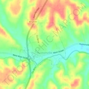
Name: Topografische Karte Hustonville, Höhe, Relief.
Ort: Hustonville, Lincoln County, Kentucky, United States (37.46910 -84.82531 37.48220 -84.80774)
Durchschnittliche Höhe: 316 m
Minimale Höhe: 283 m
Maximale Höhe: 348 m
Andere topografische Karten
Klicken Sie auf eine Karte, um ihre Topografie, ihre Höhe und ihr Relief anzuzeigen.
Stanford
United States > Kentucky > Lincoln County
Stanford, Lincoln County, Kentucky, United States
Durchschnittliche Höhe: 292 m
Kings Mountain
United States > Kentucky > Lincoln County
Kings Mountain, Lincoln County, Kentucky, 40442, United States
Durchschnittliche Höhe: 375 m
Blue Lick
United States > Kentucky > Lincoln County
Blue Lick, Lincoln County, Kentucky, 40484, United States
Durchschnittliche Höhe: 336 m
logan hubble park
United States > Kentucky > Lincoln County
logan hubble park, Lincoln County, Kentucky, United States
Durchschnittliche Höhe: 267 m
Crab Orchard
United States > Kentucky > Lincoln County
Crab Orchard, Lincoln County, Kentucky, United States
Durchschnittliche Höhe: 283 m