
Topografische Karte Riverdale
Interaktive Karte
Klicken Sie auf die Karte, um die Höhe anzuzeigen.
Über diese Karte
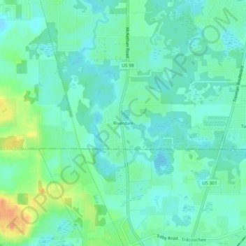
Name: Topografische Karte Riverdale, Höhe, Relief.
Ort: Riverdale, Hernando County, Florida, 33593, United States (28.46278 -82.21620 28.50278 -82.17620)
Durchschnittliche Höhe: 24 m
Minimale Höhe: 13 m
Maximale Höhe: 52 m
Andere topografische Karten
Klicken Sie auf eine Karte, um ihre Topografie, ihre Höhe und ihr Relief anzuzeigen.
Brooksville
United States > Florida > Hernando County
Brooksville, Hernando County, Florida, United States
Durchschnittliche Höhe: 29 m
Ridge Manor
United States > Florida > Hernando County > Ridge Manor
Ridge Manor, Brooksville, Hernando County, Florida, United States
Durchschnittliche Höhe: 22 m
Pine Island
United States > Florida > Hernando County > Pine Island
Pine Island, Hernando County, Florida, United States
Durchschnittliche Höhe: 1 m
Timber Pines
United States > Florida > Hernando County > Timber Pines
Timber Pines, Hernando County, Florida, United States
Durchschnittliche Höhe: 12 m
Berkeley
United States > Florida > Hernando County > Berkeley
Berkeley, Hernando County, Florida, 34606, United States
Durchschnittliche Höhe: 10 m
Spring Hill
United States > Florida > Hernando County
Spring Hill, Hernando County, Florida, United States
Durchschnittliche Höhe: 18 m
Weeki Wachee
United States > Florida > Hernando County
Weeki Wachee, Hernando County, Florida, United States
Durchschnittliche Höhe: 11 m