
Vielen Dank für die Unterstützung dieser Website ❤️
Spenden
Spenden
Topografische Karte Malangas
Klicken Sie auf die Karte, um die Höhe anzuzeigen.
Vielen Dank für die Unterstützung dieser Website ❤️
Spenden
Spenden
Malangas
Malangas also includes the island of Muyong, having endowed with white sand beaches, and other of uninhabited islands near the shorelines. Mainland area are steeply sloping terrain of hills and mountains. Due to its topography and elevation the town do not experience flooding.
Vielen Dank für die Unterstützung dieser Website ❤️
Spenden
Spenden
Über diese Karte
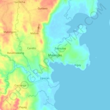
Name: Topografische Karte Malangas, Höhe, Relief.
Durchschnittliche Höhe: 38 m
Minimale Höhe: -4 m
Maximale Höhe: 172 m
Vielen Dank für die Unterstützung dieser Website ❤️
Spenden
Spenden
Andere topografische Karten
Klicken Sie auf eine Karte, um ihre Topografie, ihre Höhe und ihr Relief anzuzeigen.