
Vielen Dank für die Unterstützung dieser Website ❤️
Spenden
Spenden
Topografische Karte Sindangan
Klicken Sie auf die Karte, um die Höhe anzuzeigen.
Vielen Dank für die Unterstützung dieser Website ❤️
Spenden
Spenden
Sindangan
Since its elevation to a municipality in 1936, people from Luzon and the Visayas continued migrating to Sindangan to settle together with their families and built businesses. That is why aside from the Subanens, there are Sindanganons whose origins are from Bohol, Cebu, Samar, Leyte, Negros, Bicol, Pampanga, and Manila.
Vielen Dank für die Unterstützung dieser Website ❤️
Spenden
Spenden
Über diese Karte
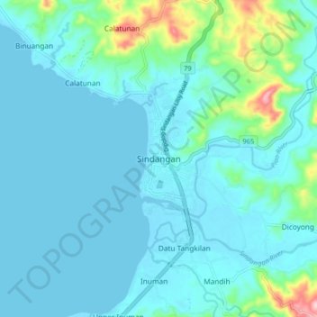
Name: Topografische Karte Sindangan, Höhe, Relief.
Durchschnittliche Höhe: 30 m
Minimale Höhe: -2 m
Maximale Höhe: 220 m
Vielen Dank für die Unterstützung dieser Website ❤️
Spenden
Spenden
Andere topografische Karten
Klicken Sie auf eine Karte, um ihre Topografie, ihre Höhe und ihr Relief anzuzeigen.