
Topografische Karte Milford Sound
Interaktive Karte
Klicken Sie auf die Karte, um die Höhe anzuzeigen.
Über diese Karte
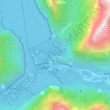
Name: Topografische Karte Milford Sound, Höhe, Relief.
Durchschnittliche Höhe: 304 m
Minimale Höhe: -4 m
Maximale Höhe: 1.538 m
Andere topografische Karten
Klicken Sie auf eine Karte, um ihre Topografie, ihre Höhe und ihr Relief anzuzeigen.
The Key
New Zealand > Southland > Southland District > Fiordland Community
The Key, Fiordland Community, Southland District, Southland, 9672, New Zealand
Durchschnittliche Höhe: 325 m
Te Anau
New Zealand > Southland > Southland District > Fiordland Community
Te Anau, Fiordland Community, Southland District, Southland, 9600, New Zealand
Durchschnittliche Höhe: 249 m
Manapouri
New Zealand > Southland > Southland District > Fiordland Community
Manapouri, Fiordland Community, Southland District, Southland, 7969, New Zealand
Durchschnittliche Höhe: 213 m