
Topografische Karte Isabela
Klicken Sie auf die Karte, um die Höhe anzuzeigen.
Isabela
The province is divided into three physiographic areas. The eastern area, straddled by the Sierra Madre mountain range, is rugged and thickly forested. A substantial portion is uncharted. These unexplored hinterlands are home to a rich variety of flora and fauna, and some are under government reservations. It is home to one of the world's largest remaining low-altitude rainforests, with numerous unknown endemic species of flora and fauna and biological diversity in the protected area known as the Northern Sierra Madre Natural Park. Isabela has 600,000 hectares (1,500,000 acres) of Cagayan Valley’s 900,000 hectares (2,200,000 acres) of forest cover.
Über diese Karte
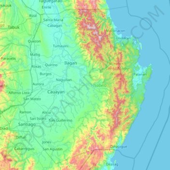
Name: Topografische Karte Isabela, Höhe, Relief.
Ort: Isabela, Cagayan Valley, Philippines (16.39443 121.33589 17.56891 122.66939)
Durchschnittliche Höhe: 227 m
Minimale Höhe: -1 m
Maximale Höhe: 1.796 m
Andere topografische Karten
Klicken Sie auf eine Karte, um ihre Topografie, ihre Höhe und ihr Relief anzuzeigen.
Quezon City
Founded as a pueblo by Saint Pedro Bautista in 1590, San Francisco del Monte may be considered Quezon City's oldest district. The original land area of the old town of San Francisco del Monte was approximately2.5 square kilometres (1.0 sq mi) and covered parts of what is currently known as Project 7 and 8 and…
Durchschnittliche Höhe: 57 m
San Juan
"San Juan" is a contraction of the city's traditional name of "San Juan del Monte" (lit. 'Saint John of the Mountain'). As with numerous other places in the Philippines, the name combines a patron saint and a toponym; in this case Saint John the Baptist with the locale's hilly terrain and relatively higher…
Durchschnittliche Höhe: 35 m
Malolos
Malolos is relatively flat of about 0.81% to a gently sloping of 2.17%. The slope of the land descends towards west, southwest to southern direction. The highest land elevation is at about 6.0 meters above sea level while the lowest is only half a meter below sea level. A network of natural waterways and…
Durchschnittliche Höhe: 6 m
Lake Sebu
The placid lake of Lake Sebu can be found in Allah Valley near the municipality of Surallah, South Cotabato. Surrounded by rolling hills and mountains covered with thick rain forest, the lake has an area of 361.124 hectares (892.36 acres), with an elevation of approximately 1,000 metres (3,300 ft).
Durchschnittliche Höhe: 750 m
Valencia
The city's topography is characterized as flat to undulating hills with extensive plateaus and mountainous areas and cliffs on both eastern and western portions bounding the municipality of San Fernando on the east and the municipality of Talakag on the west. Its highest point is Mount Kalatungan in the…
Durchschnittliche Höhe: 566 m
Bacolod
Bacólod (English: Bacolod), is derived from bakólod (Old Spelling: bacólod), the Old Hiligaynon (Old Ilonggo) (Old Spelling: Ylongo and Ilongo) word for a "hill, turtle, mound, rise, hillock, down, any small eminence or elevation", since the resettlement was founded on a stony, hilly area, now the barangay…
Durchschnittliche Höhe: 49 m
Sipocot
Sipocot spans a total land area of approximately 218.60 square kilometers, making it one of the larger municipalities in Camarines Sur in terms of land size. Its topography is a mix of coastal plains, rolling hills, and forested uplands, with various rivers and streams contributing to the local ecosystem and…
Durchschnittliche Höhe: 61 m
Kibungan
The municipality is within a cool highland mountainous zone with elevations at more than 2,500 metres (8,200 ft) above sea level. During its coolest months of December to January, Barangay Madaymen experiences chilling temperature of 0 °C (32 °F), causing the famous Frost of Madaymen.
Durchschnittliche Höhe: 1.242 m
Mandaue
It is one of the two (the other one being the municipality of Consolacion) local government units located within the mainland Metro Cebu where the elevation of land is less than 100 m (330 ft).
Durchschnittliche Höhe: 109 m
Mandaluyong
Another claims that the Spaniards named the place based on the report of a navigator named Acapulco, who saw the rolling hills frequently being lashed at by daluyong (“big waves from the sea”). This seems to confirm traditional pre-Hispanic stories that giant waves from the sea would meet the adjoining…
Durchschnittliche Höhe: 33 m
Vigan
Vigan is situated in a Quaternary Age sedimentary plain called the Vigan-Bantay Plain which is part of the Ilocos coastal plain. The Vigan-Bantay Plain is bounded on the east by a moderately rugged Miocene sediments consisting of interbedded sandstones and shale to very rugged Meta-volcanics and Meta sediment…
Durchschnittliche Höhe: 63 m
Zamboanga City
Philippines > Zamboanga Peninsula > Zamboanga City
The overall topography of the city could be described as rolling to very steep. There are some flat lands, mostly narrow strips along the east coast. The urban center is mostly flat with a gentle slope to the interior, ranging from 0 to 3%. The highest registered elevation is 1,200 metres. In terms of slope, a…
Durchschnittliche Höhe: 83 m
Baguio
In 1903, Filipinos, Japanese and Chinese workers were hired to build Kennon Road, the first road directly connecting Baguio with the lowlands of La Union and Pangasinan. Before this, the only road to Benguet was Naguilian Road, and it was largely a horse trail at higher elevations. Camp John Hay was…
Durchschnittliche Höhe: 881 m
San Juan
"San Juan" is a contraction of the city's traditional name of "San Juan del Monte" (lit. 'Saint John of the Mountain'). As with numerous other places in the Philippines, the name combines a patron saint and a toponym; in this case Saint John the Baptist with the locale's hilly terrain and relatively higher…
Durchschnittliche Höhe: 35 m
Alburquerque
The central part of municipality, from the east extending toward northwest is characterized by rolling to moderately steep terrain (18-30% slope), with ground elevation ranging from 80 to 131 m (262 to 430 ft) amsl. The area in northeastern and southwestern part is characterized by steep terrain (30–50%…
Durchschnittliche Höhe: 36 m
Ilagan
Abuan River is the main river of the Northern Sierra Madre Natural Park. It has an average elevation of 82 meters above sea level, and feeds the Abuan watershed in the city. Tourists and visitors can explore the diverse animal and plant life in one of the country’s remaining lush virgin forests. On January…
Durchschnittliche Höhe: 123 m