
Topografische Karte Larwill
Interaktive Karte
Klicken Sie auf die Karte, um die Höhe anzuzeigen.
Über diese Karte
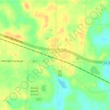
Name: Topografische Karte Larwill, Höhe, Relief.
Ort: Larwill, Whitley County, Indiana, United States (41.17594 -85.62979 41.18382 -85.61589)
Durchschnittliche Höhe: 288 m
Minimale Höhe: 270 m
Maximale Höhe: 301 m
Andere topografische Karten
Klicken Sie auf eine Karte, um ihre Topografie, ihre Höhe und ihr Relief anzuzeigen.
Etna
United States > Indiana > Whitley County
Etna, Whitley County, Indiana, United States
Durchschnittliche Höhe: 284 m
Columbia City
United States > Indiana > Whitley County
Columbia City, Whitley County, Indiana, 46725, United States
Durchschnittliche Höhe: 261 m
South Whitley
United States > Indiana > Whitley County
South Whitley, Whitley County, Indiana, 46787, United States
Durchschnittliche Höhe: 248 m