
Topografische Karte Souli Municipality
Interaktive Karte
Klicken Sie auf die Karte, um die Höhe anzuzeigen.
Über diese Karte
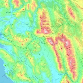
Name: Topografische Karte Souli Municipality, Höhe, Relief.
Durchschnittliche Höhe: 423 m
Minimale Höhe: -1 m
Maximale Höhe: 1.627 m
Andere topografische Karten
Klicken Sie auf eine Karte, um ihre Topografie, ihre Höhe und ihr Relief anzuzeigen.
Arillas
Greece > Epirus and Western Macedonia > Thesprotia Regional Unit > Perdika
Arillas, Perdika, Igoumenitsa Municipality, Thesprotia Regional Unit, Epirus, Epirus and Western Macedonia, 460 30, Greece
Durchschnittliche Höhe: 94 m
Neraida
Greece > Epirus and Western Macedonia > Thesprotia Regional Unit > Neraida
Neraida, Souli Municipality, Thesprotia Regional Unit, Epirus, Epirus and Western Macedonia, 46200, Greece
Durchschnittliche Höhe: 197 m
Φιλιάτες
Greece > Epirus and Western Macedonia > Thesprotia Regional Unit > Φιλιάτες
Φιλιάτες, Filiates Municipality, Thesprotia Regional Unit, Epirus, Epirus and Western Macedonia, 46300, Greece
Durchschnittliche Höhe: 253 m
Prodromi
Greece > Epirus and Western Macedonia > Thesprotia Regional Unit > Prodromi
Prodromi, Souli Municipality, Thesprotia Regional Unit, Epirus, Epirus and Western Macedonia, 46200, Greece
Durchschnittliche Höhe: 316 m