
Topografische Karte Battleship Texas State Historic Park
Interaktive Karte
Klicken Sie auf die Karte, um die Höhe anzuzeigen.
Über diese Karte
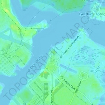
Name: Topografische Karte Battleship Texas State Historic Park, Höhe, Relief.
Durchschnittliche Höhe: 3 m
Minimale Höhe: -2 m
Maximale Höhe: 14 m
Andere topografische Karten
Klicken Sie auf eine Karte, um ihre Topografie, ihre Höhe und ihr Relief anzuzeigen.
Lake Houston
Lake Houston, Pine Cone Drive, Sherwood Trails, Houston, Harris County, Texas, 77339, USA
Durchschnittliche Höhe: 20 m
Rummel Creek
Rummel Creek, Houston, Harris County, Texas, TX 77043, USA
Durchschnittliche Höhe: 28 m
Alligator Alley
Alligator Alley, Houston, Harris County, Texas, 773345, USA
Durchschnittliche Höhe: 20 m
Edith L. Moore Nature Sanctuary
Edith L. Moore Nature Sanctuary, Houston, Harris County, Texas, USA
Durchschnittliche Höhe: 26 m