
Topografische Karte Lower Swell
Klicken Sie auf die Karte, um die Höhe anzuzeigen.
Über diese Karte
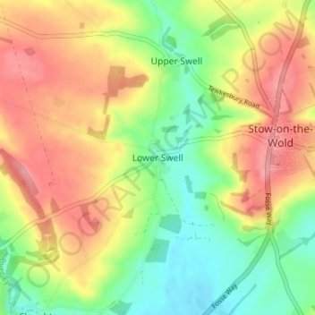
Name: Topografische Karte Lower Swell, Höhe, Relief.
Durchschnittliche Höhe: 188 m
Minimale Höhe: 136 m
Maximale Höhe: 241 m
Andere topografische Karten
Klicken Sie auf eine Karte, um ihre Topografie, ihre Höhe und ihr Relief anzuzeigen.
Donnington
United Kingdom > England > Gloucestershire > Cotswold District
Durchschnittliche Höhe: 168 m
Andoversford
United Kingdom > England > Gloucestershire > Cotswold District
Durchschnittliche Höhe: 188 m
South Cerney
United Kingdom > England > Gloucestershire > Cotswold District
Durchschnittliche Höhe: 93 m
Moreton-in-Marsh
United Kingdom > England > Gloucestershire > Cotswold District
Durchschnittliche Höhe: 135 m
Bibury
United Kingdom > England > Gloucestershire > Cotswold District
The parish is approximately rectangular and stretches far to the rolling, elevated, north. It includes on outlying settlement, Ablington, in the upper valley. Bibury Farm is 300 metres (330 yd) from the village, 151 metres (495 ft) above Ordnance Datum (AOD), which is a similar elevation to much of the north.…
Durchschnittliche Höhe: 135 m
Daglingworth
United Kingdom > England > Gloucestershire > Cotswold District > Daglingworth
Durchschnittliche Höhe: 169 m
Edgeworth
United Kingdom > England > Gloucestershire > Cotswold District
Durchschnittliche Höhe: 196 m
Temple Guiting
United Kingdom > England > Gloucestershire > Cotswold District
Durchschnittliche Höhe: 226 m
Worcestershire (detached)
United Kingdom > England > Gloucestershire > Cotswold District
Durchschnittliche Höhe: 103 m
Cirencester Park
United Kingdom > England > Gloucestershire > Cotswold District > Sapperton
Durchschnittliche Höhe: 162 m
Cold Aston
United Kingdom > England > Gloucestershire > Cotswold District > Cold Aston
Durchschnittliche Höhe: 189 m
Cirencester
United Kingdom > England > Gloucestershire > Cotswold District
On Cotswold Avenue is the site of a Roman amphitheatre which, while buried, retains its shape in the earthen topography of the small park setting. Cirencester was one of the most substantial cities of Roman-era Britain.
Durchschnittliche Höhe: 128 m
Upper Rissington
United Kingdom > England > Gloucestershire > Cotswold District
Durchschnittliche Höhe: 208 m
Bourton-on-the-Hill
United Kingdom > England > Gloucestershire > Cotswold District
Durchschnittliche Höhe: 200 m
Farmington
United Kingdom > England > Gloucestershire > Cotswold District
Durchschnittliche Höhe: 171 m
Little Rissington
United Kingdom > England > Gloucestershire > Cotswold District
Durchschnittliche Höhe: 171 m
Ozleworth
United Kingdom > England > Gloucestershire > Cotswold District
Durchschnittliche Höhe: 174 m
Coberley
United Kingdom > England > Gloucestershire > Cotswold District > Coberley
Durchschnittliche Höhe: 234 m
Chipping Campden
United Kingdom > England > Gloucestershire > Cotswold District
Durchschnittliche Höhe: 191 m
Bushley Muzzard, Brimpsfield
United Kingdom > England > Gloucestershire > Cotswold District > Nettleton > Watercombe
Durchschnittliche Höhe: 261 m
Knap House Quarry, Birdlip
United Kingdom > England > Gloucestershire > Cotswold District > Birdlip
Durchschnittliche Höhe: 222 m
Withington
United Kingdom > England > Gloucestershire > Cotswold District
Durchschnittliche Höhe: 212 m
Botany Bay Wood
United Kingdom > England > Gloucestershire > Cotswold District > Stow-on-the-Wold
Durchschnittliche Höhe: 171 m
Dowdeswell
United Kingdom > England > Gloucestershire > Cotswold District
Durchschnittliche Höhe: 209 m
Baunton
United Kingdom > England > Gloucestershire > Cotswold District > Baunton
Durchschnittliche Höhe: 146 m
Longborough
United Kingdom > England > Gloucestershire > Cotswold District
Durchschnittliche Höhe: 177 m
Somerford Keynes
United Kingdom > England > Gloucestershire > Cotswold District
Durchschnittliche Höhe: 92 m
Evenlode
United Kingdom > England > Gloucestershire > Cotswold District > Evenlode
Durchschnittliche Höhe: 134 m
Great Rissington
United Kingdom > England > Gloucestershire > Cotswold District > Great Rissington
Durchschnittliche Höhe: 168 m
Long Newnton
United Kingdom > England > Gloucestershire > Cotswold District
Durchschnittliche Höhe: 117 m
Tetbury Upton
United Kingdom > England > Gloucestershire > Cotswold District
Durchschnittliche Höhe: 133 m
Bagendon
United Kingdom > England > Gloucestershire > Cotswold District > Bagendon
Durchschnittliche Höhe: 171 m
Didmarton
United Kingdom > England > Gloucestershire > Cotswold District > Didmarton
Durchschnittliche Höhe: 147 m
Kingscote
United Kingdom > England > Gloucestershire > Cotswold District
Durchschnittliche Höhe: 186 m
Willersey
United Kingdom > England > Gloucestershire > Cotswold District
Durchschnittliche Höhe: 114 m
Guiting Power
United Kingdom > England > Gloucestershire > Cotswold District
Durchschnittliche Höhe: 215 m
Poulton
United Kingdom > England > Gloucestershire > Cotswold District > Poulton
Durchschnittliche Höhe: 109 m
Bourton-on-the-Water
United Kingdom > England > Gloucestershire > Cotswold District
Durchschnittliche Höhe: 155 m
Winson
United Kingdom > England > Gloucestershire > Cotswold District > Winson
Durchschnittliche Höhe: 145 m
Oddington
United Kingdom > England > Gloucestershire > Cotswold District
Durchschnittliche Höhe: 129 m
Bledington
United Kingdom > England > Gloucestershire > Cotswold District
Durchschnittliche Höhe: 116 m
Windrush
United Kingdom > England > Gloucestershire > Cotswold District > Windrush
Durchschnittliche Höhe: 155 m
Sherborne
United Kingdom > England > Gloucestershire > Cotswold District > Sherborne
Durchschnittliche Höhe: 156 m
Elkstone
United Kingdom > England > Gloucestershire > Cotswold District > Elkstone
Durchschnittliche Höhe: 234 m
Down Ampney
United Kingdom > England > Gloucestershire > Cotswold District > Down Ampney
Durchschnittliche Höhe: 85 m
Hazleton
United Kingdom > England > Gloucestershire > Cotswold District > Hazleton
Durchschnittliche Höhe: 227 m
Chedworth
United Kingdom > England > Gloucestershire > Cotswold District > Chedworth
Durchschnittliche Höhe: 187 m
Shipton Moyne
United Kingdom > England > Gloucestershire > Cotswold District
Durchschnittliche Höhe: 106 m
River Churn
United Kingdom > England > Gloucestershire > Cotswold District
Durchschnittliche Höhe: 157 m
Cherington
United Kingdom > England > Gloucestershire > Cotswold District
Durchschnittliche Höhe: 154 m
Naunton
United Kingdom > England > Gloucestershire > Cotswold District > Naunton
Durchschnittliche Höhe: 201 m
Brimpsfield
United Kingdom > England > Gloucestershire > Cotswold District
Durchschnittliche Höhe: 247 m
Driffield
United Kingdom > England > Gloucestershire > Cotswold District
Durchschnittliche Höhe: 100 m
Ampney Crucis
United Kingdom > England > Gloucestershire > Cotswold District
Durchschnittliche Höhe: 130 m
Colesbourne
United Kingdom > England > Gloucestershire > Cotswold District
Durchschnittliche Höhe: 214 m
Cirencester
United Kingdom > England > Gloucestershire > Cotswold District
On Cotswold Avenue is the site of a Roman amphitheatre which, while buried, retains its shape in the earthen topography of the small park setting. Cirencester was one of the most substantial cities of Roman-era Britain.
Durchschnittliche Höhe: 128 m
Sapperton
United Kingdom > England > Gloucestershire > Cotswold District
Durchschnittliche Höhe: 167 m
Temple Guiting
United Kingdom > England > Gloucestershire > Cotswold District
Durchschnittliche Höhe: 226 m
Chipping Campden
United Kingdom > England > Gloucestershire > Cotswold District
Durchschnittliche Höhe: 191 m
Guiting Power
United Kingdom > England > Gloucestershire > Cotswold District
Durchschnittliche Höhe: 215 m
Didmarton
United Kingdom > England > Gloucestershire > Cotswold District > Didmarton
Durchschnittliche Höhe: 147 m
Cirencester
United Kingdom > England > Gloucestershire > Cotswold District
On Cotswold Avenue is the site of a Roman amphitheatre which, while buried, retains its shape in the earthen topography of the small park setting. Cirencester was one of the most substantial cities of Roman-era Britain.
Durchschnittliche Höhe: 128 m
Edgeworth
United Kingdom > England > Gloucestershire > Cotswold District
Durchschnittliche Höhe: 196 m
Cirencester
United Kingdom > England > Gloucestershire > Cotswold District > Chesterton
On Cotswold Avenue is the site of a Roman amphitheatre which, while buried, retains its shape in the earthen topography of the small park setting. Cirencester was one of the most substantial cities of Roman-era Britain.
Durchschnittliche Höhe: 128 m