
Topografische Karte Burghclere
Klicken Sie auf die Karte, um die Höhe anzuzeigen.
Über diese Karte
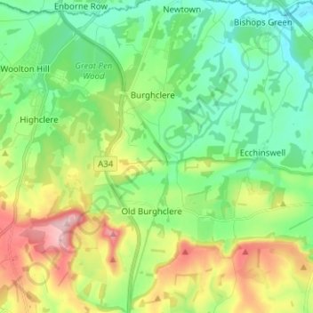
Name: Topografische Karte Burghclere, Höhe, Relief.
Durchschnittliche Höhe: 140 m
Minimale Höhe: 72 m
Maximale Höhe: 278 m
Andere topografische Karten
Klicken Sie auf eine Karte, um ihre Topografie, ihre Höhe und ihr Relief anzuzeigen.
Basingstoke
United Kingdom > England > Hampshire > Basingstoke and Deane
Situated in a valley through the Hampshire Downs at an average elevation of 88 metres (289 ft) Basingstoke is a major interchange between Reading, Newbury, Andover, Winchester, and Alton, and lies on the natural trade route between the southwest of England and London. The area had been something of an…
Durchschnittliche Höhe: 109 m
Winterhill Plantation
United Kingdom > England > Hampshire > Basingstoke and Deane > Whitchurch > Wells-In-The-Field
Durchschnittliche Höhe: 100 m
Ashford Hill
United Kingdom > England > Hampshire > Basingstoke and Deane
Durchschnittliche Höhe: 88 m
Morgaston Wood
United Kingdom > England > Hampshire > Basingstoke and Deane > Sherborne St John
Durchschnittliche Höhe: 76 m
Sherborne St John
United Kingdom > England > Hampshire > Basingstoke and Deane
Durchschnittliche Höhe: 92 m
Highclere Castle
United Kingdom > England > Hampshire > Basingstoke and Deane
Durchschnittliche Höhe: 166 m
Chapman's Dell
United Kingdom > England > Hampshire > Basingstoke and Deane
Durchschnittliche Höhe: 173 m
Woolton Hill
United Kingdom > England > Hampshire > Basingstoke and Deane
Durchschnittliche Höhe: 126 m
Basingstoke
United Kingdom > England > Hampshire > Basingstoke and Deane
Situated in a valley through the Hampshire Downs at an average elevation of 88 metres (289 ft) Basingstoke is a major interchange between Reading, Newbury, Andover, Winchester, and Alton, and lies on the natural trade route between the southwest of England and London. The area had been something of an…
Durchschnittliche Höhe: 107 m
Farleigh Hill
United Kingdom > England > Hampshire > Basingstoke and Deane
Durchschnittliche Höhe: 176 m
Bramley Corner
United Kingdom > England > Hampshire > Basingstoke and Deane > Bramley
Durchschnittliche Höhe: 69 m
Windabout Copse
United Kingdom > England > Hampshire > Basingstoke and Deane
Durchschnittliche Höhe: 80 m
East Oakley
United Kingdom > England > Hampshire > Basingstoke and Deane
Durchschnittliche Höhe: 125 m
Wolverton Common
United Kingdom > England > Hampshire > Basingstoke and Deane
Durchschnittliche Höhe: 99 m
Mapledurwell
United Kingdom > England > Hampshire > Basingstoke and Deane
Durchschnittliche Höhe: 94 m
Pamber Green
United Kingdom > England > Hampshire > Basingstoke and Deane > Tadley
Durchschnittliche Höhe: 85 m
Wolverton Townsend
United Kingdom > England > Hampshire > Basingstoke and Deane
Durchschnittliche Höhe: 106 m
Cufaude
United Kingdom > England > Hampshire > Basingstoke and Deane > Bramley
Durchschnittliche Höhe: 69 m
River Lyde
United Kingdom > England > Hampshire > Basingstoke and Deane > Up Nately
Durchschnittliche Höhe: 78 m
Cole Henley
United Kingdom > England > Hampshire > Basingstoke and Deane > Whitchurch
Durchschnittliche Höhe: 118 m
Latchmere Green
United Kingdom > England > Hampshire > Basingstoke and Deane > Little London > Latchmere Green
Durchschnittliche Höhe: 73 m
Chilton Wood
United Kingdom > England > Hampshire > Basingstoke and Deane
Durchschnittliche Höhe: 133 m
Chilton Candover
United Kingdom > England > Hampshire > Basingstoke and Deane > Chilton Candover
Durchschnittliche Höhe: 118 m
Tufton
United Kingdom > England > Hampshire > Basingstoke and Deane > Hurstbourne Priors
Durchschnittliche Höhe: 87 m
Ellisfield Green
United Kingdom > England > Hampshire > Basingstoke and Deane > Ellisfield
Durchschnittliche Höhe: 175 m
Bidden
United Kingdom > England > Hampshire > Basingstoke and Deane > Upton Grey
Durchschnittliche Höhe: 107 m
Heath End
United Kingdom > England > Hampshire > Basingstoke and Deane > East End > Heath End
Durchschnittliche Höhe: 144 m
Basingstoke
United Kingdom > England > Hampshire > Basingstoke and Deane
Situated in a valley through the Hampshire Downs at an average elevation of 88 metres (289 ft), Basingstoke is a major interchange between Reading, Newbury, Andover, Winchester and Alton. It lies on the natural trade route between the south-west of England and London. The area had been something of an…
Durchschnittliche Höhe: 107 m
Brown Candover
United Kingdom > England > Hampshire > Basingstoke and Deane
Durchschnittliche Höhe: 112 m
Basingstoke
United Kingdom > England > Hampshire > Basingstoke and Deane
Situated in a valley through the Hampshire Downs at an average elevation of 88 metres (289 ft), Basingstoke is a major interchange between Reading, Newbury, Andover, Winchester and Alton. It lies on the natural trade route between the south-west of England and London. The area had been something of an…
Durchschnittliche Höhe: 107 m
Basingstoke
United Kingdom > England > Hampshire > Basingstoke and Deane
Situated in a valley through the Hampshire Downs at an average elevation of 88 metres (289 ft) Basingstoke is a major interchange between Reading, Newbury, Andover, Winchester, and Alton, and lies on the natural trade route between the southwest of England and London. The area had been something of an…
Durchschnittliche Höhe: 107 m
Woolton Hill
United Kingdom > England > Hampshire > Basingstoke and Deane
Durchschnittliche Höhe: 126 m