
Topografische Karte Wardering
Interaktive Karte
Klicken Sie auf die Karte, um die Höhe anzuzeigen.
Über diese Karte
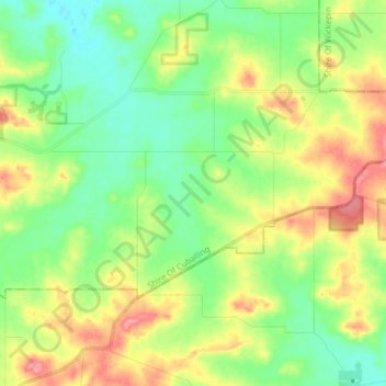
Name: Topografische Karte Wardering, Höhe, Relief.
Durchschnittliche Höhe: 354 m
Minimale Höhe: 315 m
Maximale Höhe: 421 m
Andere topografische Karten
Klicken Sie auf eine Karte, um ihre Topografie, ihre Höhe und ihr Relief anzuzeigen.
Perth
Australia > Western Australia > City of Perth
Perth, City of Perth, Western Australia, 6000, Australia
Durchschnittliche Höhe: 26 m
Busselton
Busselton, City Of Busselton, Western Australia, Australia
Durchschnittliche Höhe: 4 m
City of Perth
City of Perth, Western Australia, Australia
Durchschnittliche Höhe: 18 m
Margaret River
Australia > Western Australia > Margaret River
Margaret River, Shire Of Augusta Margaret River, Western Australia, 6285, Australia
Durchschnittliche Höhe: 94 m
Swan River
Australia > Western Australia > City of Perth
Swan River, City of Perth, Western Australia, Australia
Durchschnittliche Höhe: 57 m
Channybearup
Channybearup, Shire Of Manjimup, Western Australia, Australia
Durchschnittliche Höhe: 171 m
Albany
Albany, City Of Albany, Western Australia, 6330, Australia
Durchschnittliche Höhe: 30 m
Mandurah
Mandurah, City Of Mandurah, Western Australia, 6201, Australia
Durchschnittliche Höhe: 5 m
Bunbury
Bunbury, City Of Bunbury, Western Australia, 6230, Australia
Durchschnittliche Höhe: 14 m
Rottnest Island
Australia > Western Australia > Geordie Bay
Rottnest Island, Geordie Bay, City Of Cockburn, Western Australia, 6161, Australia
Durchschnittliche Höhe: 2 m
Kunawarritji
Kunawarritji, Shire Of East Pilbara, Western Australia, Australia
Durchschnittliche Höhe: 303 m
East Bunbury
East Bunbury, City Of Bunbury, Western Australia, Australia
Durchschnittliche Höhe: 7 m
Kalgoorlie
Kalgoorlie, City Of Kalgoorlie-Boulder, Western Australia, 6432, Australia
Durchschnittliche Höhe: 360 m
Collie
Australia > Western Australia > Collie
Collie, Shire Of Collie, Western Australia, 6225, Australia
Durchschnittliche Höhe: 210 m
Geraldton
Geraldton, City Of Greater Geraldton, Western Australia, 6530, Australia
Durchschnittliche Höhe: 33 m
Logue Brook Dam
Logue Brook Dam, Shire Of Harvey, Western Australia, Australia
Durchschnittliche Höhe: 242 m
Darkan
Darkan, Shire Of West Arthur, Western Australia, Australia
Durchschnittliche Höhe: 290 m
Lake Brockman
Lake Brockman, Shire Of Harvey, Western Australia, Australia
Durchschnittliche Höhe: 244 m
Fremantle
Australia > Western Australia > City of Fremantle > Fremantle
Fremantle, City of Fremantle, Western Australia, 6959, Australia
Durchschnittliche Höhe: 11 m
Esperance
Esperance, Shire Of Esperance, Western Australia, Australia
Durchschnittliche Höhe: 8 m
Kimberley
Kimberley, Shire Of Derby-West Kimberley, Western Australia, Australia
Durchschnittliche Höhe: 274 m
Broome
Broome, Shire Of Broome, Western Australia, 6752, Australia
Durchschnittliche Höhe: 8 m
Shire Of Cranbrook
Shire Of Cranbrook, Western Australia, Australia
Durchschnittliche Höhe: 239 m
Tenterden
Tenterden, Shire Of Cranbrook, Western Australia, Australia
Durchschnittliche Höhe: 251 m
Bobakine Nature Reserve
Australia > Western Australia > Clackline
Bobakine Nature Reserve, Katrine, Clackline, Shire Of Northam, Western Australia, Australia
Durchschnittliche Höhe: 318 m
Mokine Nature Reserve
Mokine Nature Reserve, Mokine, Shire Of Northam, Western Australia, Australia
Durchschnittliche Höhe: 279 m
Inkpen Road Nature Reserve
Inkpen Road Nature Reserve, Shire Of Northam, Western Australia, Australia
Durchschnittliche Höhe: 322 m
Nanamoolan Nature Reserve
Nanamoolan Nature Reserve, Hoddys Well, Shire Of Toodyay, Western Australia, Australia
Durchschnittliche Höhe: 333 m
Edgewater
Edgewater, City of Joondalup, Western Australia, Australia
Durchschnittliche Höhe: 33 m
George River
George River, Western Australia, Australia
Durchschnittliche Höhe: 141 m
Cartamulligan Well Nature Reserve
Australia > Western Australia > Jennacubbine
Cartamulligan Well Nature Reserve, Jennacubbine, Cunjardine, Shire Of Goomalling, Western Australia, Australia
Durchschnittliche Höhe: 196 m
Wattening Nature Reserve
Wattening Nature Reserve, Wattening, Shire Of Toodyay, Western Australia, Australia
Durchschnittliche Höhe: 241 m
Bewmalling Nature Reserve
Bewmalling Nature Reserve, Culham, Shire Of Toodyay, Western Australia, Australia
Durchschnittliche Höhe: 275 m
Mullewa
Mullewa, City Of Greater Geraldton, Western Australia, 6630, Australia
Durchschnittliche Höhe: 277 m
Mooriary
Mooriary, Shire of Mingenew, Western Australia, Australia
Durchschnittliche Höhe: 193 m
Kings Park
Australia > Western Australia > City of Perth > Perth
Kings Park, Crawley, Kings Park, Perth, City of Perth, Western Australia, Australia
Durchschnittliche Höhe: 31 m
Millendon
Millendon, City of Swan, Western Australia, Australia
Durchschnittliche Höhe: 40 m
Gracetown
Gracetown, Shire Of Augusta Margaret River, Western Australia, Australia
Durchschnittliche Höhe: 44 m
Yabberup
Yabberup, Shire Of Donnybrook-Balingup, Western Australia, Australia
Durchschnittliche Höhe: 211 m
Shire Of East Pilbara
Shire Of East Pilbara, Western Australia, Australia
Durchschnittliche Höhe: 331 m
Nambung
Nambung, Shire Of Dandaragan, Western Australia, Australia
Durchschnittliche Höhe: 50 m
Millbridge
Millbridge, Shire Of Dardanup, Western Australia, Australia
Durchschnittliche Höhe: 13 m
Boyagarring Hill
Boyagarring Hill, Shire Of Beverley, Western Australia, Australia
Durchschnittliche Höhe: 319 m
Misery Beach
Australia > Western Australia > Albany
Misery Beach, Torndirrup, Albany, City Of Albany, Western Australia, Australia
Durchschnittliche Höhe: 26 m
Mount Dale
Mount Dale, Shire Of Beverley, Western Australia, Australia
Durchschnittliche Höhe: 368 m
Bejoording
Bejoording, Shire Of Toodyay, Western Australia, Australia
Durchschnittliche Höhe: 244 m
Talbot
Talbot, Shire Of York, Western Australia, Australia
Durchschnittliche Höhe: 299 m
Warner Glen
Warner Glen, Shire Of Augusta Margaret River, Western Australia, Australia
Durchschnittliche Höhe: 29 m
Geographe
Geographe, City Of Busselton, Western Australia, Australia
Durchschnittliche Höhe: 2 m
Dirk Hartog Island
Dirk Hartog Island, Western Australia, Australia
Durchschnittliche Höhe: 5 m