Geolokalisieren
👉 Easily get elevation data in JSON, GeoTIFF and KML formats using Elevation API
Vielen Dank für die Unterstützung dieser Website ❤️
Spenden

Topografische Karte La Grande Rivière

Klicken Sie auf die Karte, um die Höhe anzuzeigen.

👉 Easily get elevation data in JSON, GeoTIFF and KML formats using Elevation API
Vielen Dank für die Unterstützung dieser Website ❤️
Spenden

Über diese Karte

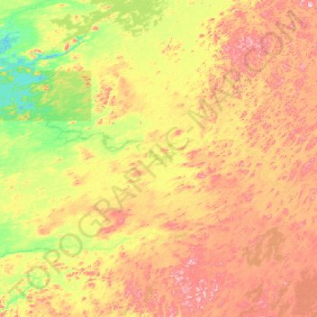
Name: Topografische Karte La Grande Rivière, Höhe, Relief.

Ort: La Grande Rivière, Quebec, Canada (53.21748 -73.46281 53.90080 -70.79041)

Durchschnittliche Höhe: 489 m

Minimale Höhe: 372 m

Maximale Höhe: 730 m

👉 Easily get elevation data in JSON, GeoTIFF and KML formats using Elevation API
Vielen Dank für die Unterstützung dieser Website ❤️
Spenden

Andere topografische Karten

Klicken Sie auf eine Karte, um ihre Topografie, ihre Höhe und ihr Relief anzuzeigen.

Montreal

Canada > Quebec > Urban agglomeration of Montreal

Durchschnittliche Höhe: 29 m

Quebec

Canada > Quebec > Urban agglomeration of Québec

Quebec City was built on the north bank of the Saint Lawrence River, where it narrows and meets the mouth of the Saint-Charles River. Old Quebec is located on top and at the foot of Cap-Diamant, which is on the eastern edge of a plateau called the promontory of Quebec (Quebec hill). Because of this topographic…

Durchschnittliche Höhe: 117 m

Gatineau

Canada > Quebec

Gatineau is located in southwestern Quebec, on the northern bank of the Gatineau River. It is situated at an elevation of around 50 m (164.042 ft) The Gatineau Hills are the foothills of the Laurentian Mountains and located in the region. It is also the location of the second largest urban park in the world.…

Durchschnittliche Höhe: 127 m

Laval (administrative region)

Canada > Quebec

Durchschnittliche Höhe: 42 m

Vielen Dank für die Unterstützung dieser Website ❤️
Spenden

Rimouski

Canada > Quebec > Rimouski-Neigette

The tide station located at Pointe-au-Père serves as the reference point for measuring mean sea level for the North American Vertical Datum of 1988, which is the reference point for determining altitude in North America.

Durchschnittliche Höhe: 126 m

Montagne des Érables

Canada > Quebec > Charlevoix-Est > Mont-Élie

Durchschnittliche Höhe: 770 m

Cantley

Canada > Quebec > Les Collines-de-l'Outaouais

Durchschnittliche Höhe: 185 m

Boisbriand

Canada > Quebec > Thérèse-De Blainville

Durchschnittliche Höhe: 39 m

Vielen Dank für die Unterstützung dieser Website ❤️
Spenden

Quebec

Canada > Quebec > Urban agglomeration of Québec

Quebec City was built on the north bank of the Saint Lawrence River, where it narrows and meets the mouth of the Saint-Charles River. Old Quebec is located on top and at the foot of Cap-Diamant, which is on the eastern edge of a plateau called the promontory of Quebec (Quebec hill). Because of this topographic…

Durchschnittliche Höhe: 100 m

Dorval

Canada > Quebec > Urban agglomeration of Montreal

Durchschnittliche Höhe: 29 m

Pointe-Claire

Canada > Quebec > Urban agglomeration of Montreal

Durchschnittliche Höhe: 30 m

Val-d'Or

Canada > Quebec > La Vallée-de-l'Or

Val-d’Or is situated on the Canadian Shield at an elevation of 1100 feet (330m) above sea level. Although its name refers to a valley (“Val”), the city is actually situated on a vast, slightly undulating plain.

Durchschnittliche Höhe: 331 m

Vielen Dank für die Unterstützung dieser Website ❤️
Spenden

Laurentides

Canada > Quebec

Durchschnittliche Höhe: 334 m

Lac Bataille

Canada > Quebec > Val-des-Monts

Durchschnittliche Höhe: 242 m

Trois-Rivières

Canada > Quebec > Trois-Rivières

Durchschnittliche Höhe: 38 m

Lévis

Canada > Quebec

Durchschnittliche Höhe: 96 m

Vielen Dank für die Unterstützung dieser Website ❤️
Spenden

Deux-Montagnes (MRC)

Canada > Quebec

Durchschnittliche Höhe: 49 m

Mount Royal

Canada > Quebec > Urban agglomeration of Montreal > Montreal

The hill is part of the Monteregian Hills situated between the Laurentians and the Appalachian Mountains. It gave its Latin name, Mons Regius, to the Monteregian chain. The hill consists of three peaks: Colline de la Croix (or Mont Royal proper) at 233 m (764 ft), Colline d'Outremont (or Mount Murray, in the…

Durchschnittliche Höhe: 111 m

Rouyn-Noranda

Canada > Quebec

Durchschnittliche Höhe: 307 m

Gaspé Peninsula

Canada > Quebec

Durchschnittliche Höhe: 190 m

Vielen Dank für die Unterstützung dieser Website ❤️
Spenden

Manawan

Canada > Quebec

Durchschnittliche Höhe: 455 m

Manicouagan

Canada > Quebec

Durchschnittliche Höhe: 437 m

Le Rocher-Percé

Canada > Quebec

Durchschnittliche Höhe: 147 m

Alma

Canada > Quebec > Lac-Saint-Jean-Est

Durchschnittliche Höhe: 129 m

Vielen Dank für die Unterstützung dieser Website ❤️
Spenden

Urban agglomeration of Montreal

Canada > Quebec

Durchschnittliche Höhe: 30 m

Sherbrooke

Canada > Quebec

Durchschnittliche Höhe: 232 m

Brome-Missisquoi

Canada > Quebec

Durchschnittliche Höhe: 182 m

Anticosti Island

Canada > Quebec

Topographically, Anticosti Island can be divided into three distinct regions: two lowland areas, rarely exceeding 150 metres (490 ft) in elevation, in the eastern and western thirds of the island linked along the coast; and a central highland forming a plateau that rises to just over 300 m (980 ft). This…

Durchschnittliche Höhe: 30 m

Vielen Dank für die Unterstützung dieser Website ❤️
Spenden

Abitibi

Canada > Quebec

Durchschnittliche Höhe: 314 m

Les Pays-d'en-Haut

Canada > Quebec

Durchschnittliche Höhe: 334 m

La Mauricie National Park

Canada > Quebec > Shawinigan

Durchschnittliche Höhe: 384 m

Saguenay–Lac-Saint-Jean

Canada > Quebec

Durchschnittliche Höhe: 449 m

Vielen Dank für die Unterstützung dieser Website ❤️
Spenden

Charlevoix

Canada > Quebec

Durchschnittliche Höhe: 593 m

Beauharnois-Salaberry

Canada > Quebec

Durchschnittliche Höhe: 44 m

Les Collines-de-l'Outaouais

Canada > Quebec

Durchschnittliche Höhe: 177 m

Laval

Canada > Quebec

Durchschnittliche Höhe: 41 m

Vielen Dank für die Unterstützung dieser Website ❤️
Spenden

Montérégie

Canada > Quebec

Durchschnittliche Höhe: 157 m

Chibougamau

Canada > Quebec

Durchschnittliche Höhe: 392 m

Lac-Simon

Canada > Quebec

Durchschnittliche Höhe: 321 m

Desmaraisville

Canada > Quebec

Durchschnittliche Höhe: 315 m

Vielen Dank für die Unterstützung dieser Website ❤️
Spenden

Gaspésie–Îles-de-la-Madeleine

Canada > Quebec

Durchschnittliche Höhe: 86 m

Jamésie

Canada > Quebec

Durchschnittliche Höhe: 344 m

Rouyn

Canada > Quebec

Durchschnittliche Höhe: 297 m

Rivière Romaine

Canada > Quebec

Durchschnittliche Höhe: 479 m

Vielen Dank für die Unterstützung dieser Website ❤️
Spenden

Monts Otish

Canada > Quebec

Durchschnittliche Höhe: 924 m

Canton de Cleveland

Canada > Quebec

Durchschnittliche Höhe: 209 m

Le Petit Cap

Canada > Quebec

Durchschnittliche Höhe: 11 m

Coulonge River

Canada > Quebec

Durchschnittliche Höhe: 318 m

Vielen Dank für die Unterstützung dieser Website ❤️
Spenden

Estrie

Canada > Quebec

Durchschnittliche Höhe: 348 m

Argenteuil

Canada > Quebec

Durchschnittliche Höhe: 189 m

Papineau

Canada > Quebec

Durchschnittliche Höhe: 232 m

Saguenay

Canada > Quebec

Durchschnittliche Höhe: 268 m

Vielen Dank für die Unterstützung dieser Website ❤️
Spenden

Rivière Péribonka

Canada > Quebec

Durchschnittliche Höhe: 487 m

Trois-Rivières

Canada > Quebec

Durchschnittliche Höhe: 39 m

Ottawa River (North)

Canada > Quebec

Durchschnittliche Höhe: 347 m

Centre-du-Québec

Canada > Quebec

Durchschnittliche Höhe: 132 m

Vielen Dank für die Unterstützung dieser Website ❤️
Spenden

L'Île-Saint-Régis

Canada > Quebec

Durchschnittliche Höhe: 49 m

Mauricie

Canada > Quebec

Durchschnittliche Höhe: 395 m

Lanaudière

Canada > Quebec

The region of Lanaudière is part of central Quebec and is located between the Saint Lawrence River and the Laurentian Mountains, between Mauricie and the Laurentides. Lanaudière attracts a good deal of interest from vacationers due to its unique character founded largely on the harmony between its culture…

Durchschnittliche Höhe: 332 m

Pontiac

Canada > Quebec

Durchschnittliche Höhe: 311 m

Vielen Dank für die Unterstützung dieser Website ❤️
Spenden

Montmagny (MRC)

Canada > Quebec

Its territory can be divided into three main geographical areas. The first is constituted of the estuary of the Saint Lawrence River and its islands. Second are the plains, which includes the Saint Lawrence Lowlands, which run from east to west and covers the northern portion of the Montmagny RCM, and is…

Durchschnittliche Höhe: 311 m

Bonaventure (MRC)

Canada > Quebec

Durchschnittliche Höhe: 230 m

L'Islet (MRC)

Canada > Quebec

Durchschnittliche Höhe: 283 m

Vielen Dank für die Unterstützung dieser Website ❤️
Spenden

Antoine-Labelle

Canada > Quebec

Durchschnittliche Höhe: 380 m

Avignon

Canada > Quebec

Durchschnittliche Höhe: 299 m

L'Assomption (MRC)

Canada > Quebec

Durchschnittliche Höhe: 24 m

La Côte-de-Gaspé

Canada > Quebec

Durchschnittliche Höhe: 148 m

Vielen Dank für die Unterstützung dieser Website ❤️
Spenden

Portneuf (MRC)

Canada > Quebec

Durchschnittliche Höhe: 316 m

Memphrémagog

Canada > Quebec

Durchschnittliche Höhe: 292 m

Le Granit

Canada > Quebec

Durchschnittliche Höhe: 475 m

La Haute-Gaspésie

Canada > Quebec

Durchschnittliche Höhe: 247 m

Vielen Dank für die Unterstützung dieser Website ❤️
Spenden

La Matapédia

Canada > Quebec

Durchschnittliche Höhe: 299 m

D'Autray

Canada > Quebec

Durchschnittliche Höhe: 166 m

La Haute-Côte-Nord

Canada > Quebec

Durchschnittliche Höhe: 348 m

Lac-Saint-Jean-Est

Canada > Quebec

Durchschnittliche Höhe: 285 m

Vielen Dank für die Unterstützung dieser Website ❤️
Spenden

Mirabel

Canada > Quebec

Durchschnittliche Höhe: 71 m

Témiscamingue

Canada > Quebec

Durchschnittliche Höhe: 318 m

Shawinigan

Canada > Quebec

Durchschnittliche Höhe: 215 m

Vaudreuil-Soulanges

Canada > Quebec

Durchschnittliche Höhe: 54 m

Vielen Dank für die Unterstützung dieser Website ❤️
Spenden

Chaleur Bay

Canada > Quebec

Durchschnittliche Höhe: 102 m

Abitibi-Témiscamingue

Canada > Quebec

Durchschnittliche Höhe: 333 m

Bas-Saint-Laurent

Canada > Quebec

The topography of Bas-Saint-Laurent has two main elements : the plateaus of the Appalachian Mountains, called Notre Dame Mountains, and the lowlands in the fine stripe of land along the Saint Lawrence river. These are separated by an intermediate area of ridges and foothills which meld with the plateaus. The…

Durchschnittliche Höhe: 285 m

Capitale-Nationale

Canada > Quebec

Durchschnittliche Höhe: 375 m

Vielen Dank für die Unterstützung dieser Website ❤️
Spenden

Chaudière-Appalaches

Canada > Quebec

Durchschnittliche Höhe: 323 m

Côte-Nord

Canada > Quebec

Durchschnittliche Höhe: 327 m

Nord-du-Québec

Canada > Quebec

Durchschnittliche Höhe: 215 m

Outaouais

Canada > Quebec

Durchschnittliche Höhe: 318 m

Vielen Dank für die Unterstützung dieser Website ❤️
Spenden

Rivière Saint-Maurice

Canada > Quebec

Durchschnittliche Höhe: 391 m

Rivière Nottaway

Canada > Quebec

Durchschnittliche Höhe: 219 m

Rivière Broadback

Canada > Quebec

Durchschnittliche Höhe: 261 m

Rivière Arnaud

Canada > Quebec

Durchschnittliche Höhe: 218 m

Vielen Dank für die Unterstützung dieser Website ❤️
Spenden

Kativik

Canada > Quebec

Durchschnittliche Höhe: 168 m

Sept-Rivières

Canada > Quebec

Durchschnittliche Höhe: 413 m

L'Île-Perrot

Canada > Quebec > Vaudreuil-Soulanges

Durchschnittliche Höhe: 33 m

Otter Lake

Canada > Quebec > Pontiac

Durchschnittliche Höhe: 262 m

Vielen Dank für die Unterstützung dieser Website ❤️
Spenden

Saint-Antonin

Canada > Quebec > Rivière-du-Loup (MRC)

Durchschnittliche Höhe: 188 m

Morin-Heights

Canada > Quebec > Les Pays-d'en-Haut

Durchschnittliche Höhe: 348 m

Oka

Canada > Quebec > Deux-Montagnes (MRC)

Durchschnittliche Höhe: 58 m

Vielen Dank für die Unterstützung dieser Website ❤️
Spenden